
The area of the Canary Islands is a zone of moderate seismicity, with earthquakes that, in general, do not exceed 5.5 degrees of magnitude. In many cases, it is a question of seismicity associated with volcanic reactivations, which may or may not end in an eruption. The seismic series usually begin with low magnitude earthquakes, which increase in frequency and size until they are widely felt. In many cases, migrations of the epicenters and changes in the depth of the earthquakes are also observed along the same series. This type of activity is related to the dynamics of magma intrusion and sometimes, it can be accompanied by other signs of volcanic reactivation such as ground deformation, gas emanation, gravimetric anomalies, etc. Historically, most of the volcanic eruptions in the Canary Islands have been preceded or accompanied by felt earthquakes (Romero, 1991). Some more recent examples of seismic series associated with volcanic reactivations in the Canary Islands are the Tenerife series in 2004 (Domíguez Sardinia et al., 2011), the successive reactivations in El Hierro between 2011 and 2014 (Domínguez Sardinia et al., 2018) and in La Palma in 2017 and 2018 (López et al., 2018).
On the other hand, in the Canary Archipelago, located in the Atlantic zone of the African plate, there is also seismic activity due to regional tectonics. This second type of activity can, in turn, give rise to earthquakes of considerable magnitude. A clear example is the earthquake of magnitude 5.2 that occurred between the islands of Tenerife and Gran Canaria on May 9, 1989 (Mezcua et al., 1992).
The first seismic station of the National Geographic Institute in the Canary Islands was installed in 1952 in Santa Cruz de Tenerife, and in 1975 its number was increased with another two in El Hierro and La Palma. From that moment on, the first location with exclusively instrumental data was produced, giving rise to what is known as the instrumental era. However, in those years, the number of total stations was too low to be able to detect earthquakes of magnitude less than 3 throughout the archipelago and for the locations to be reliable. Although two new stations were installed in 1990, making a total of five, it was not until 2002-2003 that five new stations were installed and we can say that the seismic network in the Canary Islands, with a number between 10 and 15 stations, is acceptable for monitoring seismicity. At present, the seismic network of the Canary Islands of the National Geographic Institute is made up of more than 50 stations that transmit data in real time to an automatic analysis and location system.
- Domínguez-Cerdeña, I., C. del Fresno y L. Rivera (2011). New insight on the increasing seismicity during Tenerife's 2004 volcanic reactivation. J. Volcanol. Geotherm. Res. 206, 15–29.
- Domínguez Cerdeña, I., L. García-Cañada, M.A. Benito-Saz, C. del Fresno, H. Lamolda, J. Pereda de Pablo, C. Sánchez Sanz (2018). On the relation between ground surface deformation and seismicity during 2012–2014 successive magmatic intrusions at El Hierro Island. Tectonophysics, 744, 422-437. https://doi.org/10.1016/j.tecto.2018.07.019.
- López, C., V. Villasante-Marcos, I. Domínguez Cerdeña, H. Lamolda, N. Luengo-Oroz, C. del Fresno, J. Pereda, P.A. Torres González, L. García-Cañada, E. González-Alonso, A. Fernández-García, S. Meletlidis y M.J. Blanco (2018). On the origin of the 2017 seismovolcanic activity in La Palma. 20th EGU General Assembly, EGU2018, Proceedings from the conference held 4-13 April, 2018 in Vienna, Austria, p.7694.
- Mezcua, J., E. Buforn, A. Udías y J. Rueda (1992). Seismotectonics of the Canary Islands. Tectonophysics 208, 447-452.
- Romero, C. (1991). Las manifestaciones volcánicas históricas del Archipiélago Canario. Tomo I. Gobierno de Canarias (Consejería de Política Territorial), Tenerife. 695 pp.
They are located in the Atlantic Ocean, 100 km from the coastal edge of the Sahara, within the African plate. The western continental margin of Africa is a passive edge with no volcanic activity.
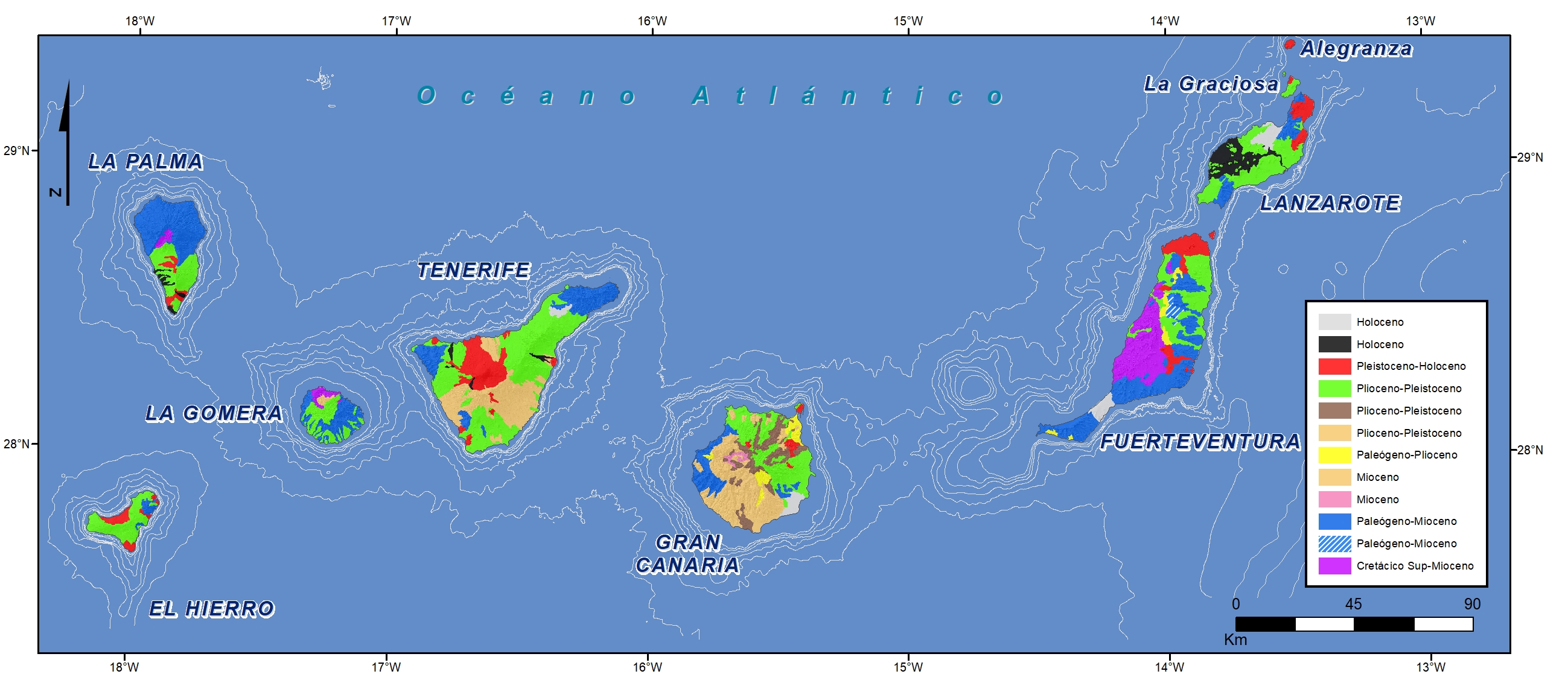
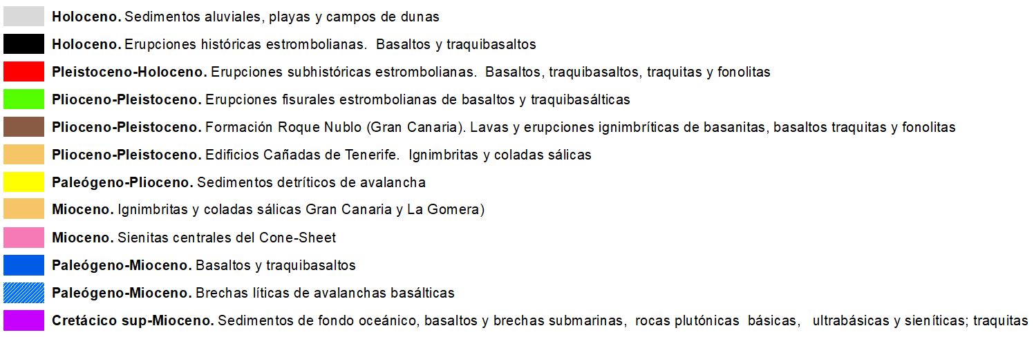
The archipelago is made up of seven major islands and some smaller ones which, together with important underwater relief in their regional environment, form an extensive volcanic province.
Four of the islands have had historical eruptions and the rest have been subhistoric. Therefore, it is a volcanologically active archipelago.
All subaerial volcanic activity has been concentrated in the last 20 Ma.
The two eastern islands, Lanzarote and Fuerteventura, emerge on a transitional crust that aligns in a N30ºE direction, more or less parallel to the African coast. They form part of an arched volcanic corridor that includes large underwater banks such as the Concepción, Dacia or Anika banks, which are 1,000 km long.
The other five islands are on Jurassic-age oceanic crust, rising from 4,000-5,000 m in depth. The subaerial phase is much younger. The oldest islands are Fuerteventura and Lanzarote and the youngest are the westernmost, La Palma 4 Ma and El Hierro 2-1.7 Ma. There is thus a certain polarity in the emissions which move from east to west which is reminiscent (not entirely) of hot spot dynamics.
Quaternary fault tectonic structures are not conspicuous, however there are folded Cretaceous sedimentary structures in the Fuerteventura Basal Complex.
The seismicity of the Canary Islands archipelago is of moderate magnitude, shallow and closely linked to historical or more recent eruptive phases such as: the southern third of La Palma, the southern half of El Hierro (the highest concentration of epicenters) or the historical volcanoes of the NW Tenerife rif (Chahorra volcano, Chinyero volcano) of the S rif (Vilaflor volcanoes) and the Dorsal rif axis (Siete Fuentes a Arafo eruptive axis). Also of special importance is the seismicity between the islands of Tenerife and Gran Canaria, which reaches the highest magnitudes of the archipelago, up to M 5.5.
| © Instituto Geográfico Nacional - C/ General Ibáñez de Ibero, 3. 28003 Madrid - España.
ign@fomento.es |


