
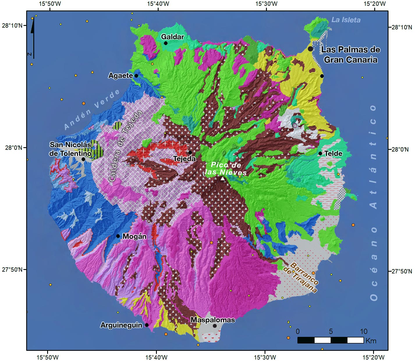
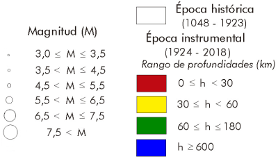
Seismicity on the island of Gran Canaria is very low. There is no specific focus of epicentres. The few earthquakes that do exist are scattered in the marine area more or less near the coast.
Gran Canaria has a circular shape with a diameter of approximately 46 km and rests on an ocean floor at a depth of 4,000 m. Its maximum altitude is the Pico de las Nieves, with 1,949 m, located in the centre of the island, and is affected by a deep network of ravines in a radial arrangement.
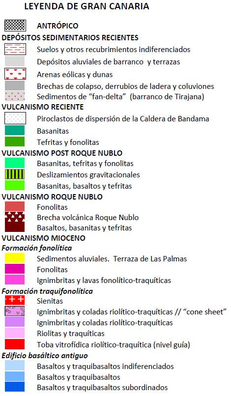
Gran Canaria is a geologically mature island where the relief presents more features of erosion than volcanic modelling. It has been active for at least the last 15-14 Ma and there is no volcanic activity at present. Evolved mafic magmas generated an extreme compositional spectrum as well as large explosive saline eruptions. It had an underwater growth phase from the ocean floor, the age of which is unknown. However, oceanographic studies of the island's underwater environment estimate that 90% of the total volume corresponds to this phase.
There are two well-marked domains on the island: the Southwest domain or Paleocanaria, which is geologically the oldest on the island and where the hydrographic network is most embedded, and the Northeast domain or Neocanaria, occupied by the most recent strombolian volcanic eruptions (< 3 Ma), which has a somewhat smoother surface. It is speculated that both domains are separated by a fault line.
Its geological history, after its emergence, begins about 14 Ma (middle Miocene) with the rapid emission of a large volume of basaltic flows (more than 1,000 km3), which built a shield volcanic building (Miocene building), with maximum heights of 2,000 m and a diameter similar to that of the current island. The distribution of the network of dikes draws a convergent pattern that indicates that the center of the building was to the west of Tejeda. Practically without solution of continuity, the magmatism of the island evolved towards felic terms with the emission, from the center of the island, of pyroclastic lavas and washes (ignimbrites) of trachytes, rhyolites and phonolites (13.9-13.3 Ma). The basaltic emission meant a sudden magma drainage, and the ceiling of the magmatic chamber collapsed producing the formation of a collapsing boiler (Caldera de Tejeda, elliptical shape, with an axis longer than 20 km, in E-W direction, and another shorter one of 16-18 km, in N-S direction. The edge has dips to the interior of 40o45o in the central area of the building. The salic materials practically covered the previous basaltic pile. They were highly explosive eruptions of a very violent plinean type. The boiler was progressively filled with salt units and an intense injection of cone-sheet salt dikes was installed in the central part during the last eruptive pulses. This cone-sheet structure forms an ellipsoidal intrusive complex with dimensions of 13-14 km of major axis and 10-11 km of minor axis, with its centre located under the Roque Bentaiga. The syenite bodies are discontinuous and small outcrops between the cone-sheet dikes, which, in many cases, represent more than 90% of the visible rock.
Salt emissions continued with the extensive Phonolithic Formation (upper Miocene). Lavas and phonolytic pyroclastics covered a large part of all the above materials. The NE flank of the Miocene basaltic building was much lower than the outcrops on the west coast. The eruptive centers of this formation were located in the area of Cruz Grande, and a large phonolithic building could be created in the center-west of it, from which most of the materials were emitted. After all the saltwater eruptions, an intense erosive process reduced all the reliefs of the island to form a powerful sedimentary formation of sand and alluvial conglomerates called the Las Palmas Detritic Formation, which emerged massively near the city of Las Palmas and, to a lesser extent, in the southern part of the island. It marks the end of the first volcanic cycle of the Miocene era. An eruptive hiatus between the first and second cycle produced a significant period of eruptive inactivity of almost 4.0 Ma.
The Roque Nublo cycle (from 5-4.5 to 3.5-3 Ma). The Pliocene building Roque Nublo was a stratovolcano of about 3,500 m high built in the centre of the island on the central paleo-relieves of Miocene volcanism. Between 4.4 and 3.4 Ma, the large emission of this cycle occurs from the centre of the island. The materials were emitted radially, occupying a wide area over the entire surface of the island. The cycle is composed of a continuous series of basanites and tephrites, although, in the beginning, basaltic lavas were also extruded. But the most characteristic unit of the whole was the violent explosive phenomena that deposited unwelded ignimbritic breccias (the Roque Nublo breccia) and large bundles of avalanche debris deposits. Slip breccia deposits extended mainly to the S, N, and NE, and represent the lateral collapses of the building. The large central plateau, of which the well-known Roque Nublo is a part, includes both an ignimbritic breccia, and sliding deposits. Towards the final stages of this cycle, numerous domes or pythons intrude into the central areas of the island. Considered as a whole, they seem to be distributed along a band of direction N115o0-125oE, which extends from Artenara, in the northwest, to the vicinity of Valsequillo, in the southeast. This direction is repeated later during the Post Roque Nublo Cycle and recent episodes, constituting one of its dominant volcanic structural guidelines.
The Post-Rocco Nublo Cycle (3.2 Ma) is characterised by the practically continuous emission of very alkaline, basanite-nepheline basic magmas in medium-sized strombolian eruptions. It was only emitted in the NE half of the island along a NW-SE diagonal from Agaete to near the mouth of the Tirajana ravine, constituting the NE or Neocanaria domain. The maximum observed thickness of these piles is 500 m.
The recent cycle corresponds to the last eruptions on the island before the conquest of the archipelago in the 15th century. They are spatially located in the NE half of the island, forming strombolian cone clusters. They are episodes less than 300,000 years old, of the same basic nature as the previous ones, which were channelled through pre-existing ravines. The youngest date obtained corresponds to the Montañón Negro volcano (5 km north of Tejeda), dated at 3,075 years. In the SE half of La Isleta, there is a 2.5 km long eruptive fissure, with a direction N300E, which continues along the sea, like an incipient rift axis.
| © Instituto Geográfico Nacional - C/ General Ibáñez de Ibero, 3. 28003 Madrid - España.
ign@fomento.es |


