

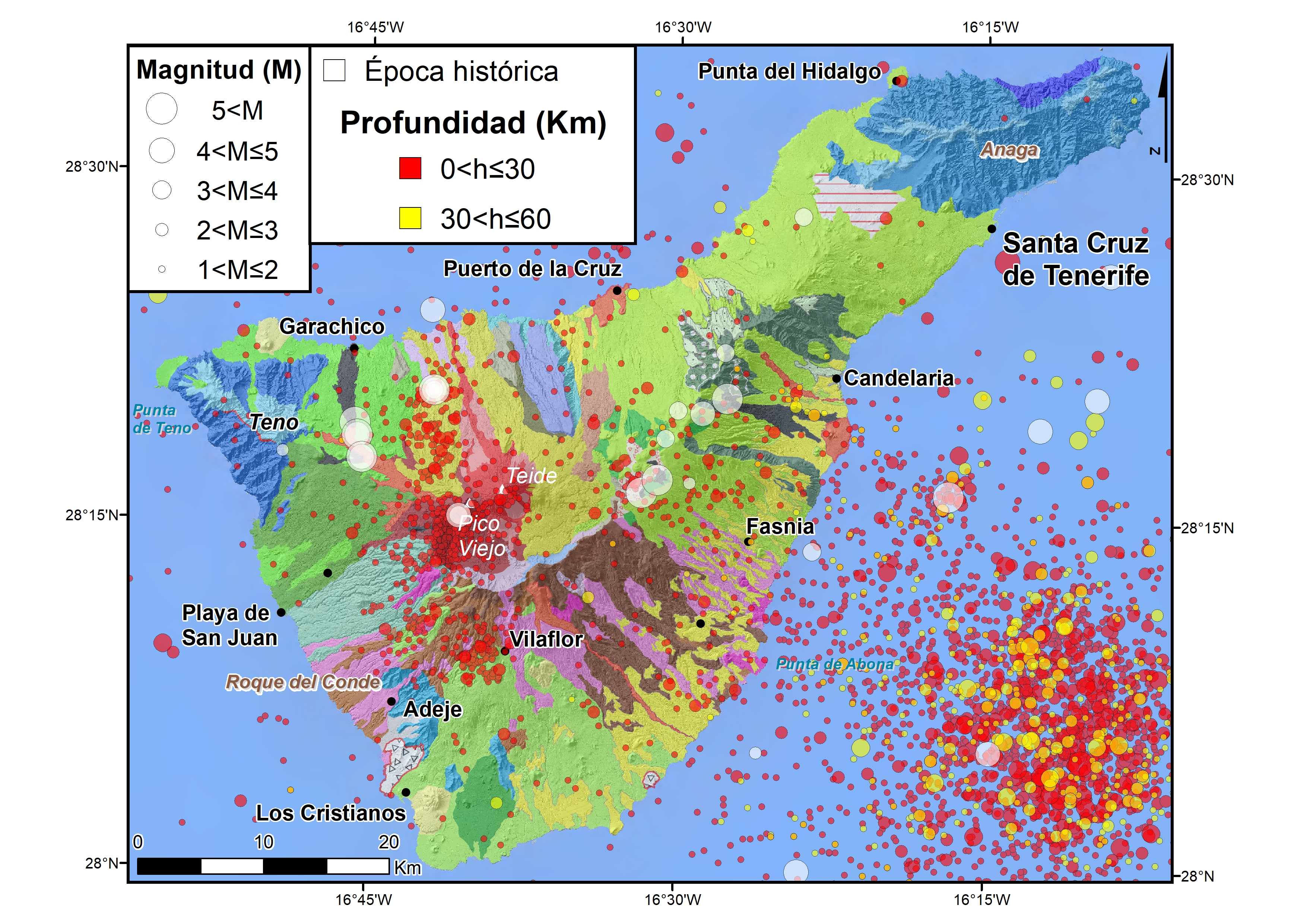
Historically, the seismicity of the island of Tenerife has been closely related to volcanic activity. The earthquakes associated with the triple eruption of Sietefuentes, Fasnia and Arafo between 1704 and 1705 (Sánchez-Sanz, 2014) stand out for their great intensity.
Currently, Tenerife is by far the most active island of the archipelago and on average there are about 1000 to 1200 earthquakes a year. In addition to this background seismicity, there are occasionally intense swarms of very low magnitude earthquakes, located in certain regions of the volcanic building. The first swarm of which we have a good record and location occurred mainly in May 2004, although it continued during 2005. The earthquakes of this series were distributed in two groups, one in the surroundings of the town of Icod de los Vinos and the other in the surroundings of Vilaflor. During this series, the events in general did not exceed the magnitude of 2.0 and in no case 3.0 (Domínguez Cerdeña et al., 2011). Other notable seismic zones on the island are: the western zone of Caldera de las Cañadas, where two swarms of hundreds of very low magnitude earthquakes were located in a few hours on October 2, 2016 and July 14, 2019; the Izaña zone, with a lot of activity between 2009 and early 2011; the surroundings of Pico del Teide, where there is recurrent seismicity, most notably the magnitude 3 earthquake of January 6, 2017. 0; and finally, at the end of 2017 low magnitude activity appeared again in the surroundings of Vilaflor that has been maintained intermittently since then (Domínguez Cerdeña et al, 2019).
- Domínguez Cerdeña, I., C. del Fresno and L. Rivera (2011). New insight on the increasing seismicity during Tenerife's 2004 volcanic reactivation. J. Volcanol. Geotherm. Res. 206, 15-29.
- Domínguez Cerdeña, I., C. del Fresno, E. Díaz, A. Muñoz, R. Rodríguez, J. Domínguez, J. Rueda (2019). Magmatic plumbing system beneath Tenerife traced by seismic activity. American Geophysical Union, Fall Meeting 2019, abstract #V51J-023.
- Sanchez Sanz, C. (2014). Review of the Seismic Catalogue of the Canary Islands. End of Degree Project, E.T.S. Ing. Topography, Geodesy and Cartography, Universidad Politécnica de Madrid, 329 pp.
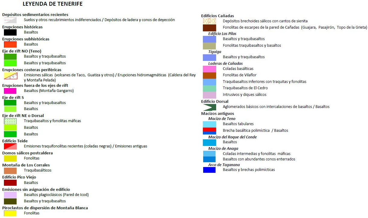
The island of Tenerife is the emerged part of a large pyramid-based volcanic pile that rises from 3,000 m deep to 3,718 m at its highest elevation, the Pico del Teide. The first subaerial volcanic materials of the island emerged about 12 million years ago, on the northern coast of the Anaga peninsula. They were basaltic emissions from large magmatic chambers that formed three separate sectors that probably formed three independent islands: the Anaga peninsula, the Teno peninsula and the Roque del Conde sector.
Anaga represents only the southern half of an island that extended northward, but that marine erosion and successive landslides have made it disappear. The oldest formation is a substratum of basaltic lava injected from many dikes that outcrops in the sector of Taganana. Large strombolian buildings with massive pyroclastic cones were erected on this substrate, from which basaltic lavas emerged and were piled up leaning, preferably towards the south and southeast, in the upper parts. The Teno peninsula is made up of two large formations: a basaltic lava pile 6.5 Ma slightly inclined towards the west and crossed by many basaltic dikes. A major destructive event caused the sliding of part of this formation and generated a very thick brechoidal deposit (several meters). Massive basaltic flows were emitted over the depression occupied by the breccia in a subhorizontal arrangement. Roque del Conde represents the isolated remains of a building whose dimensions and relationship with the outcrops of the Teno Peninsula are unknown. It is a pile of basaltic flows crossed by few dikes. The whole complex has been surrounded by lava from later periods.
Without solution of continuity with the first basaltic phase, the volcanism moved to the center of the island. 4 Ma and until only 170,000 years ago, successive explosive saline eruptions built several central volcanic buildings that overlapped each other: the Edificios Cañadas. They reached heights of about 4000 m and their emission ele moved from the Llano de Ucanca (SW) to the Montaña Blanca (NE) area. The flanks extended beyond the current coastline to the north and south of the island and progressively covered parts of the ancient massifs of Anaga, Teno and Roque del Conde.
It is known as Building or Dorsal Mountain Range to the elongated relief, with two opposite slopes, linking the massif of Anaga with the Cañadas del Teide. It is made up of a powerful pile of basaltic flows that slope gently towards the coast, on both slopes. Its formation was controlled by one of the three rift axes of the volcanism of Tenerife. On each slope there are two large depressions open to the sea: the valleys of La Orotava and Güimar, formed by large slides whose fragmented deposits form "debris" fans on the sea floor.
The Cañadas buildings collapsed giving rise to a large elliptical structure (16 km of major axis and 10 km of minor axis) probably formed in different phases, and whose current bottom is at an altitude of 2,100 m. It has walls that reach 500 m in height (Guajara's base). It is an incomplete boiler since the northern wall collapsed and slid into the sea in the Icod de los Vinos landslide. Its place was taken by the post-boiler eruptions that occupied the great depression ( Pico Viejo, El Teide, Salt Domes) and, sometimes, the flows reached the sea, on the north coast.
On many oceanic islands, elongated radial promontories tend to stand out due to rift zones. Rift zones are linear structures of cortical fractures associated with an area of underground extension. In Tenerife there are three main rift axes that begin at the three vertices of the island and converge at a triple point in the central zone, where the Edificios Cañadas and the large Teide-Pico Viejo complex emerged. In the period between 1.0 Ma and 0.5 Ma, and the more recent non-historical ones, several strombolian volcanoes emitted basaltic flows on the NE-SW axis (today inactive) that covered the previous outcrops on both slopes of the ridge. In the NW axis of Teno, today active, the same thing happened as in the previous axis. Many strombolian eruptions emitted a large amount of basaltic flows on both sides of the slope covering part of the old Teno Massif and previous emissions from Cañadas. Finally, in the third NS axis, two large strombolian cone fields covered part of the slopes of Cañadas and the old Roque del Conde massif. In this axis there is an intense seismic activity in the head of the volcanic field, near Vilaflor.
The volcanic resurgence in the interior of the Caldera de Las Cañadas, returns to where the emission centers of the Cañadas Buildings were. The result of greater dimensions is the so-called Teide-Pico Viejo Complex, a set of compound stratovolcanoes. The Teide is a stratovolcano of basanites and mafic phonolites that rises to 3,718 m and is crowned by a crater with fumarolic activity. Pico Viejo is another 3,134 m high stratovolcano composed of basalts and basanites. It has the biggest crater of the whole archipelago and in its SW slope an eruptive fissure was opened in 1798 that caused the eruption of the Chahorra volcano. Nowadays it is an active zone of recurrent seismicity. The historical eruptions are of small dimensions and, most of them located in the NW axis of Teno.
| © Instituto Geográfico Nacional - C/ General Ibáñez de Ibero, 3. 28003 Madrid - España.
ign@fomento.es |


