
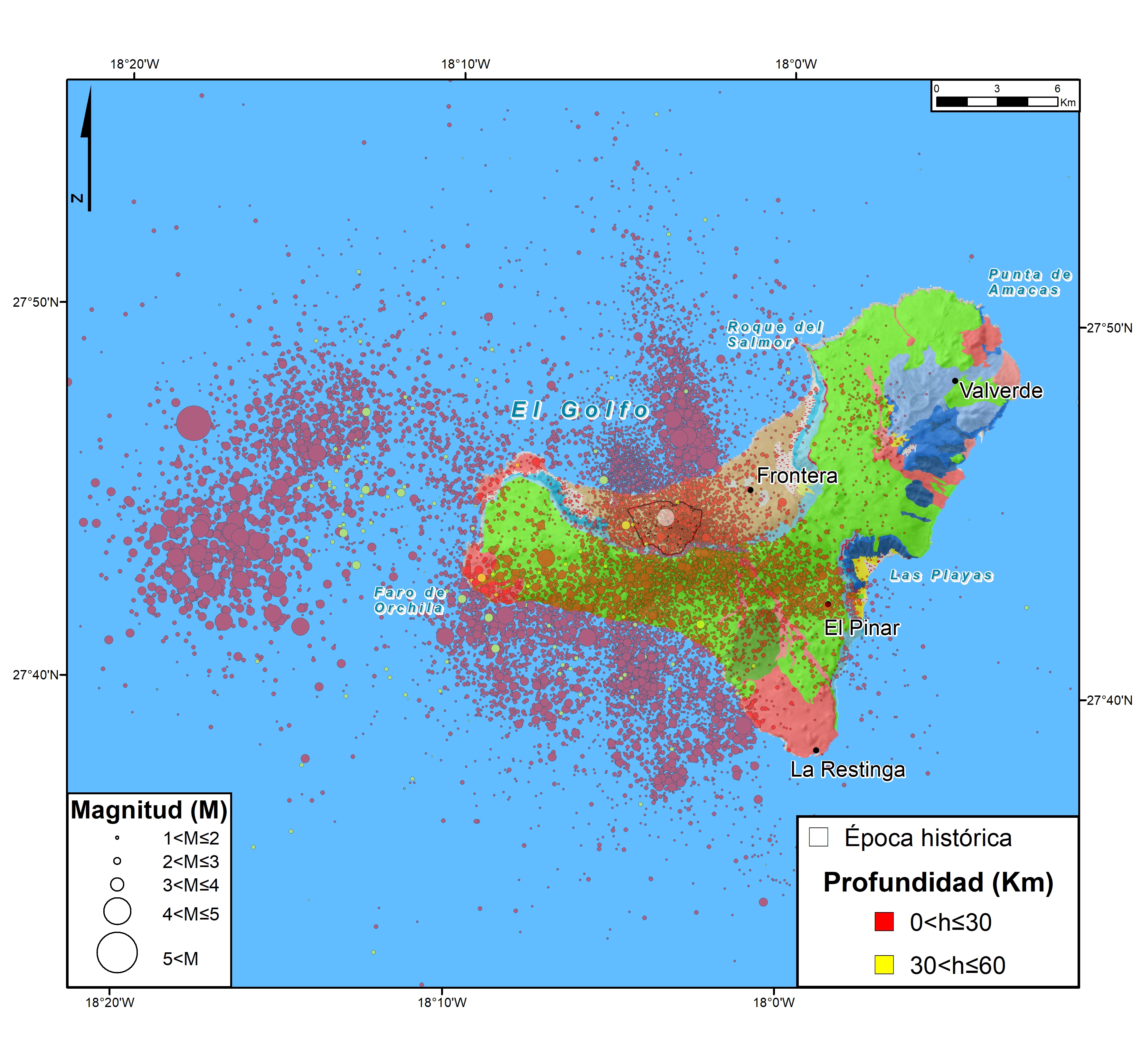
The historical seismicity record of El Hierro is limited to a major seismic crisis on the island in 1793 (Darias and Padrón, 1980). As for the instrumental period, before the underwater eruption of 2011, the number of earthquakes recorded was scarce and very dispersed, being an event of magnitude 4.5 that occurred in 2003 the largest of those located.
In July 2011, a dramatic increase in seismicity begins, preceding the underwater eruption in the south of the island that began on October 10, 2011 (Lopez et al., 2017). Thus, during the months of July to October of this same year, some 17,000 earthquakes occur (Díaz Suárez et al 2019). During this crisis, small earthquakes are initially located in the central zone of the island and at a depth of between 10 and 15 km, the events are migrating southward with the appearance of larger and larger earthquakes, culminating with the earthquake that occurred in the sea on October 8 of magnitude 4.3 in the southwest of the island and at a depth of 12 km, 32 hours before the beginning of the eruption. During the eruption, the highest magnitude seismicity was located in the area of El Golfo, in the north of the island, with two earthquakes of magnitude 4.4 and 4.6 in mid-November 2011.
Once the eruption was over, new seismic crises were recorded around the island, including the June/July 2012 and March 2013 earthquakes, the latter with nine earthquakes of more than 4.5 magnitude and maximum intensities of IV (EMS98) in the populations of the island. Finally, the earthquake of 27 December 2013, of magnitude 5.1, also located in the west of the island and with maximum intensity V (EMS98), should be highlighted. From April 2014 to date the number of earthquakes recorded is much lower.
- Darias and Padrón, D.V. (1980). General historical news about the island of El Hierro, one of the Canary Islands. Goya Publishing House, Santa Cruz de Tenerife, 2nd edition
- Díaz Suárez, E.A., I. Domínguez Cerdeña, C. del Fresno, J. Galván Fraile and J. Medina Hernández (2019). Automatic detection system tested in the 2011 pre-eruptive unrest of El Hierro eruption. American Geophysical Union, Fall Meeting 2019, abstract #V51J-0235.
- López, C., M.A. Benito-Saz, J. Martí, C. del-Fresno, L. García-Cañada, H. Albert and H. Lamolda (2017). Driving magma to the surface: The 2011-2012 El Hierro Volcanic Eruption, Geochem. Geophys. Geosyst. 18, 3165-3184, doi:10.1002/2017GC007023.
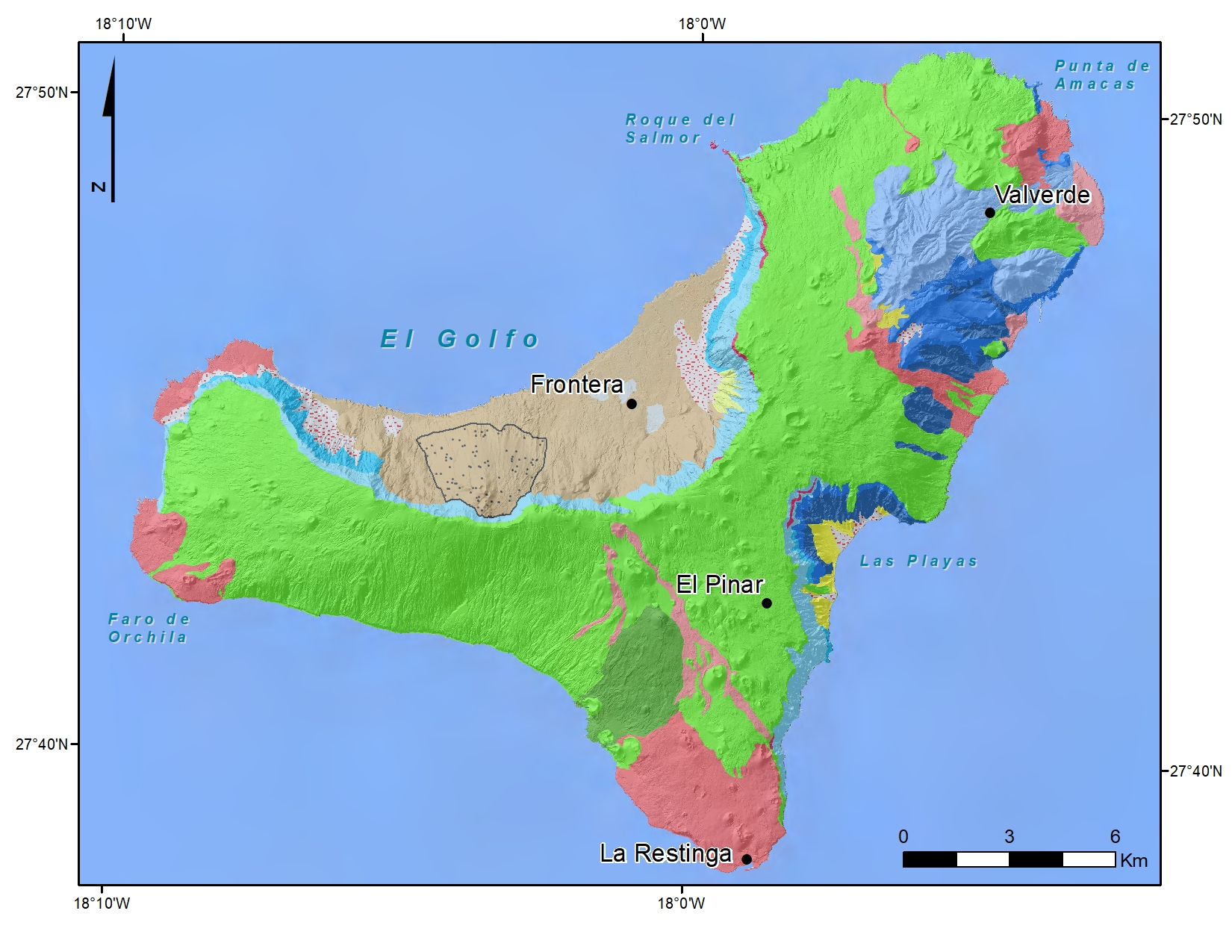
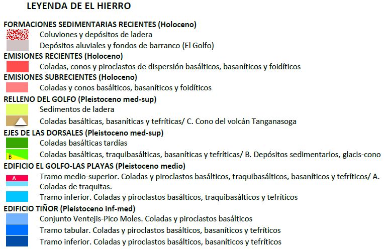
The island of El Hierro Its relief is quite cliff, with a pseudo-triangular shape and a surface area of 268.71 km². Superficially it is controlled by three structural alignments (rift axes) that converge in its central zone which reaches a maximum height of 1,503 m at the Malpaso vertex. At the southern vertex, the volcanic axis has an arched underwater continuity of more than 50 km in length. This submarine ridge is active and the 2011 submarine eruption took place on it.
Given its size, El Hierro is one of the proportionally highest and deepest mid-slope islands in the world. Within it we can distinguish three geological domains formed by a multitude of strombolian-type eruptions. Tiñor Domain: This is preferably located in the NE area and includes the first volcanic building on the island representing the shielded basaltic phase that emerged 1.7 Ma to 0.88 Ma ago. It is mostly only visible in the Ventejis area and in the windows that erosion has caused on the El Golfo-Las Playas Domain. Compositionally, basalts were emitted along with subordinate basanites and tephrites. The dyke swarms are almost all basaltic s.l., following two direction patterns: One radial, and another converging towards the SW zone of San Andrés, which would have to be the central emission area of the building construction.
The Domain El Gofo-Las Playas comprises the second stratovolcanic building that was superimposed, practically, on the whole Domain. It is located on the escarpment of the arch of El Golfo and in the upper middle part of the arch of Las Playas. Its construction began after the Tiñor Building suffered a large slide on its western flank. The emissions took place between 0.54 and 0.176 Ma and were mostly basaltic and trachybaltic. The eruptions culminated in the emission of trachitic flows that emerged along the El Golfo escarpment, from the Roques de Salmor to the base of the Hoya de Fileba. At the northern end of the El Golfo cliff these flows appear slightly tilted by several normal faults in a N60ºE direction and a sunken lip towards the north. In the south-eastern sector, they appear in the arch of Las Playas. This unit was dated at about 0.176 Ma. The spatial layout of the philonian network of this building adopts a radial arrangement with three branches that converge in the area near the Cruz de los Reyes (1.3 km east of the Malpaso vertex), which would coincide with the hypothetical central area of the Tiñor Building.
After the El Golfo-Las Playas Building, the so-called Dorsal Volcanism or structural rift axes began. The activity was concentrated along three convergent rift axes, which form an island with a pseudo-triangular plan and a pyramidal profile. Ages ranged from 0.158 to -0.012 Ma. Their eruptions were basaltic and trachybaltic.
Among the domains, we can also distinguish the domain of El Golfo filling. The valley of El Golfo was created during the middle period of the volcanism of the ridges as a result of a large slide of more than 300 km3 that destroyed the NW area of the island. The "debris" are found in fans on the sea floor as demonstrated by bathymetric studies. Likewise, they have been found in galleries that run into the slopes of El Golfo and are buried by the basic flows that fill the depression. Post-movement volcanism was concentrated in the corridors of a triple rift, ranging in age from 145 Ka to 2,500 years, with probable prehistoric eruptions. Most of the emission centres that emerged in the depression are located on the steep slopes of the headwaters of El Valle, close to the structural axis.
The recent and recent emissions arise from isolated volcanic buildings that appear within the structural axis but which stand out for their better state of conservation than the previous emissions. Its basic flows have given rise to a coastal platform that has made the island grow, mainly at the end of La Restinga.
El Hierro has had only one historic eruption. From July 19, 2011 a large number of earth tremors began to be felt. As the intensity and frequency of the earthquakes increased, the population was alerted to a possible eruption. The first eruption observed by indirect means was perceived in the sea, 5 km from the island, on 10 October 2011 with the emission of gases that stained the sea. In March 2012, the eruption ended. The Tagoro volcano was formed, more than 300 m above the sea floor and its summit was 86 m below the surface. Since then, part of the walls have been collapsing to the bottom of the sea.
| © Instituto Geográfico Nacional - C/ General Ibáñez de Ibero, 3. 28003 Madrid - España.
ign@fomento.es |


