
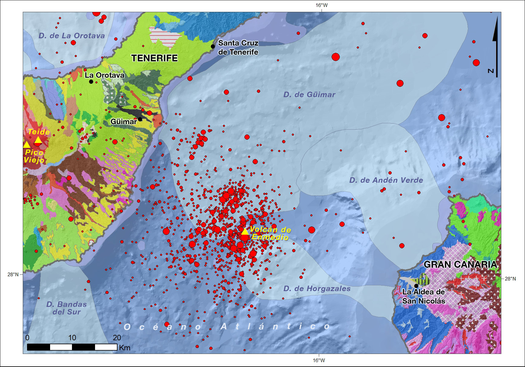
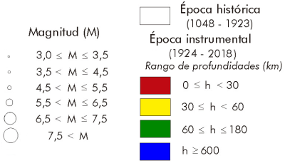
The area with the highest seismic activity in the Canary Islands, not directly related to volcanic activity, is located in the channel between the islands of Gran Canaria and Tenerife. In this zone a continuous amount of earthquakes is concentrated located since seismic instrumentation is deployed. Nowadays there are about 400-500 earthquakes per year in this zone, of which between 5 and 7 are of magnitude bigger than 2.5. The seismicity is produced at depths between 0 and 40 km. It was in this area where one of the biggest earthquakes in the Canary Islands occurred during the last 50 years, on May 9, 1989 with a magnitude of 5.2 and which was widely felt in the islands of Tenerife and Gran Canaria (Mezcua et al., 1992).
The origin of this seismicity is still under discussion today. The zone coincides with the existence of a prominent underwater volcano known as Volcán de En medio, whose last eruption has an unknown date, although the first studies of the 1989 earthquake ruled out the volcanic origin of this seismicity (Mezcua et al., 1992). Recently, Blanco-Montenegro et al. (2018) propose the presence of faults, although closer to the island of Gran Canaria and finally Barbero et al. (2018) have discovered the existence of a relative movement of approximation between the two islands due to a hydrostatic adjustment of Tenerife and that could explain the existence of this seismicity.
- Barbero, C. Torrecillas, G. Prates, R. Páez, J. Gárate, A. García, M. Berrocoso (2018). Assessment of ground deformation following Tenerife's 2004 volcanic unrest (Canary Islands). Journal of Geodynamics Volume 121, November 2018, Pages 1-8
- Blanco-Montenegro, I., F.G. Montesinos and J. Arnoso (2018). Aeromagnetic anomalies reveal the link between magmatism and tectonics during the early formation of the Canary Islands. Sci Rep 8, 42. https://doi.org/10.1038/s41598-017-18813-w
- Mezcua, J., E. Buforn, A. Udías and J. Rueda (1992). Seismotectonics of the Canary Islands. Tectonophysics 208, 447-452.
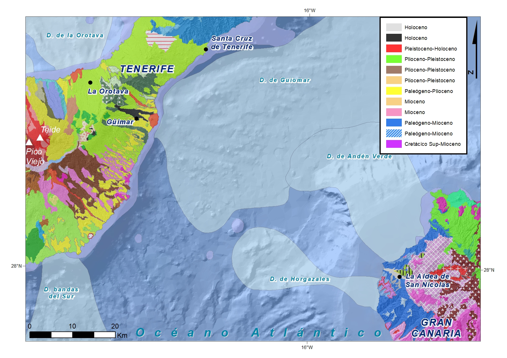
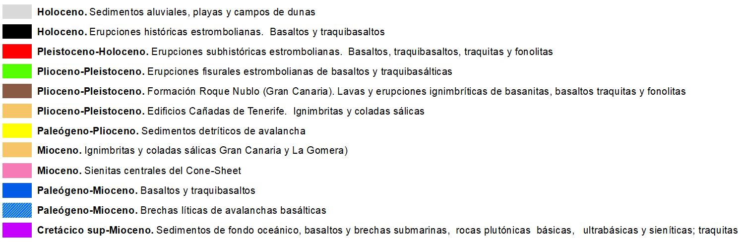
On the abyssal basaltic plain between the two islands, there are some structural and morphological elements of first magnitude. The main ones are:
Slides. The theory of large landslides on volcanic islands says that large rock avalanche deposits are created on the ocean floor around the Canary Islands. These are large underwater deposits in the form of a fan that open up at the foot of the avalanches, on the abyssal plain.
On the ocean floor between Tenerife and Gran Canaria there are large extensions of mobilized "debris" deposits that cover part of the ocean floor. Of the various prehistoric landslides described on the southern coast of the island of Tenerife, the Güimar landslide (2,600 km2), which occurred some 800,000 years ago, stands out. The depression that remains on the slope is between 9 and 12 km wide and has large lateral (up to 300 m) and headland escarpments, and within it are the landslide deposits that did not reach the sea, interspersed with new historical and subhistoric eruptions. Its headwaters coincide with the Cordillera Dorsal, the main rift zone of the island, with a NE direction, and maximum heights of 1700-2200 m.
The range of "avalanche debris" on the ocean floor on the coast of Tenerife comes from this landslide and has a volume of materials >120 km3.
For its part, the west coast of the island of Gran Canaria has also suffered several gravitational slides on the high cliffs of the Miocene basaltic building on both sides of the Aldea de San Nicolás ravine. In the southern sector (Güi-Güi, and ravines of Tasarte and Tasartico) large volumes of mainly basaltic rocks collapsed to the bottom of the sea forming "debris" fans that do not seem to overlap with that of Güimar. On the other hand, in the northern sector, the biggest cliffs of the island, such as the Anden Verde and Risco de Faneque, have also suffered bigger slides, leaving a big range of "debris" that does overlap with Güimar's.
The Enmedio fault is an area with permanent (though not currently) seismic and volcanic activity that is not episodic. According to all the earthquakes that have occurred in the area of the fault are of tectonic origin. The length of the main fault is estimated at about 35 km and is located very close to the Enmedio volcano. The recorded earthquakes usually have their hypocenter between 25 and 35 km deep, most of them, although some have been recorded at average depths of up to 70 km.
The Enmedio volcano is an underwater volcano that is located 25.47 km from the Abona lighthouse (coast of Tenerife) and 36.2 km from the village of San Nicolas (Gran Canaria).
• Height: 470 m from the bottom
• Base: 2.88 km
• Depth: 2,100 m is the base
In 1989 there was one of the largest earthquakes in the area: one of 5.2 degrees Richter, with about thirty aftershocks. The earthquake was felt throughout the island of Tenerife (with special emphasis on the east coast) and to a much lesser extent on the nearby islands of La Palma, Gran Canaria, La Gomera and El Hierro.
Currently, there is no known activity and it is likely that if there were, it would not be noticed on the surface given the depth at which it is found. Very close to the main cone, there are two other small cones of 100 m high.
| © Instituto Geográfico Nacional - C/ General Ibáñez de Ibero, 3. 28003 Madrid - España.
ign@fomento.es |


