
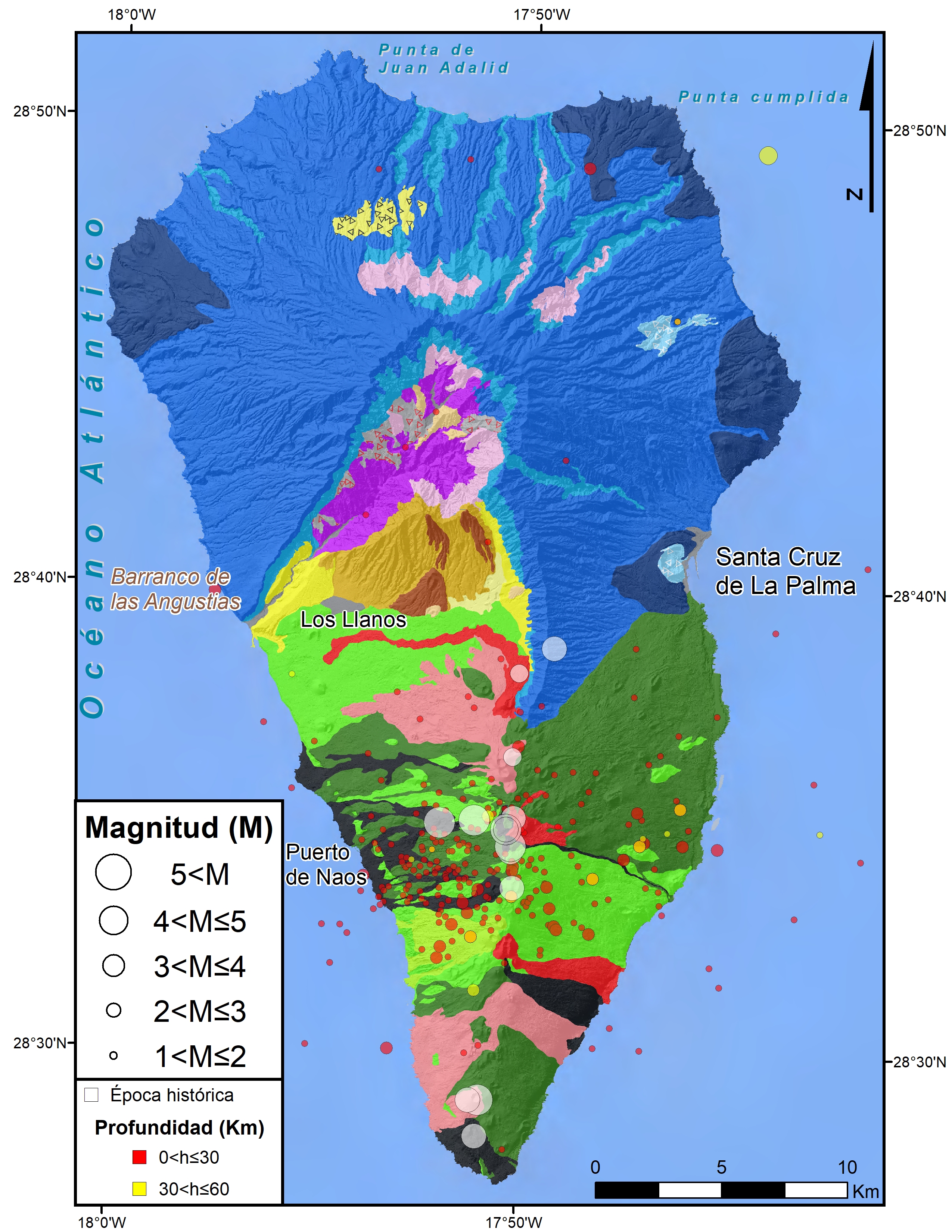
The island of La Palma has had quite a lot of historical seismicity due mostly to volcanic activity, however since the 1980s it has recorded very few earthquakes, even the seismic swarms near the towns of Los Canarios and El Pueblo, with a diffuse epicentral distribution running in an east-west direction. These swarms occurred in October 2017, with about 300 earthquakes detected at a depth of about 25 km and in February 2018 with about 1000 slightly deeper earthquakes, in both cases of very little magnitude and only a small part of them could be located (López et al., 2018). Since then, the localized seismicity is very low.
In the non-instrumental era, numerous earthquakes occurred before and during the volcanic eruptions of 1430, 1585, 1646, 1677, 1949 or 1971 (Romero 1991) and also in the years 1920, 1936 or 1939 that although not directly related to eruptions were possibly related to magmatic activity. To emphasize 3 earthquakes of the eruption of the San Juan Volcano of 1949 and one of the San Antonio volcano in 1677 with maximum intensities of VII (EMS98) and that caused the destruction of houses, rock falls and other damages.
- López, C., V. Villasante-Marcos, I. Domínguez Cerdeña, H. Lamolda, N. Luengo-Oroz, C. del Fresno, J. Pereda, P.A. Torres González, L. García-Cañada, E. González-Alonso, A. Fernández-García, S. Meletlidis and M.J. Blanco (2018). On the origin of the 2017 seismovolcanic activity in La Palma. 20th EGU General Assembly, EGU2018, Proceedings from the conference held 4-13 April, 2018 in Vienna, Austria, p.7694.
- Romero, C. (1991). The historical volcanic manifestations of the Canary Archipelago. Volume I. Government of the Canary Islands (Department of Territorial Policy), Tenerife. 695 pp.
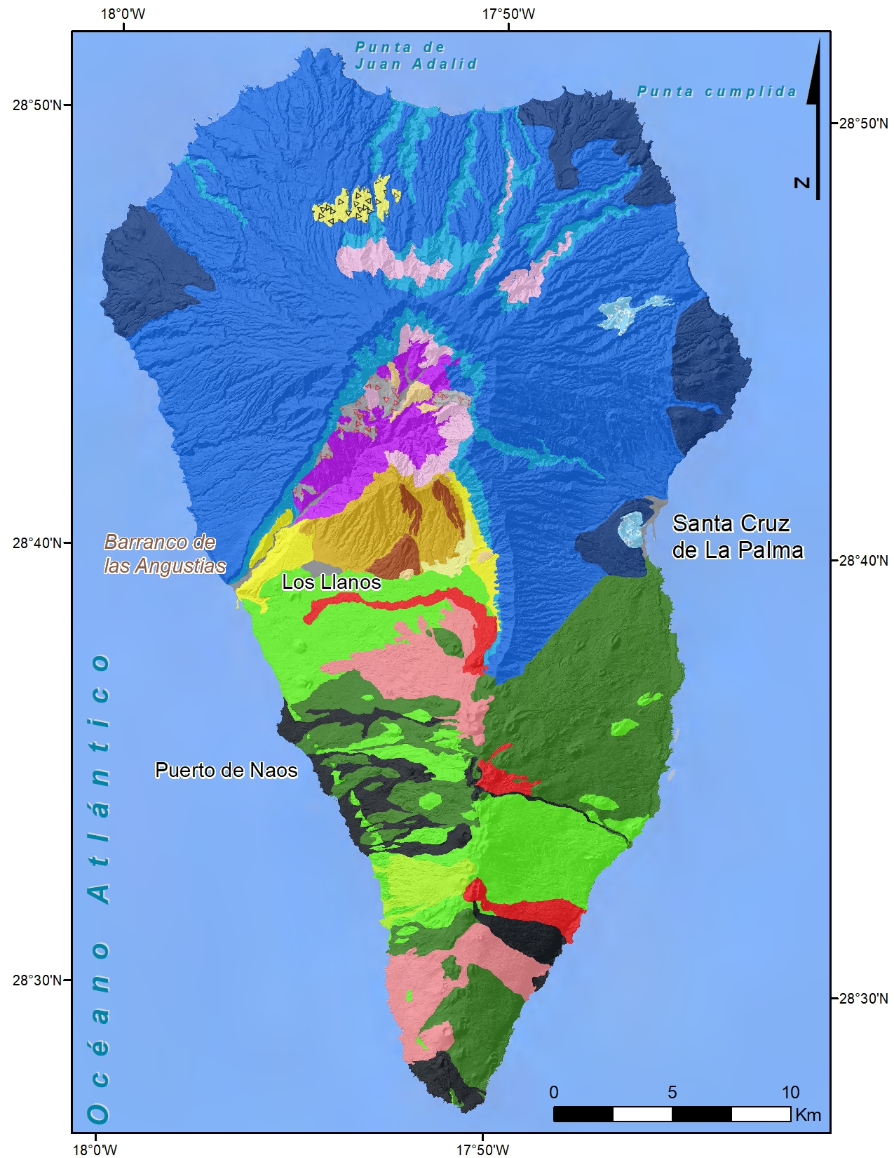
On the island of La Palma, two volcanic domains can be distinguished: the rounded northern third, or Taburiente domain, and the elongated dorsal domain from Taburiente to the southern tip of the island.
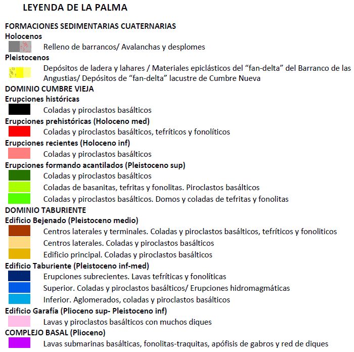
The Taburiente domain is an enormous truncated cone shaped relief with a semicircular plant that currently rises to 2,426 m (Roque de los Muchachos), with a large central depression of erosive origin: the Caldera de Taburiente. It has its origin in the superposition of large central volcanoes (stratovolcanoes) whose craters have followed one another by progressive reactivation, always in the same place. Since the island's emergence, successive subaerial volcanic stages have piled up materials vertically to heights of over 3,000 m. The result of these constructive processes is the circular form that presents the domain, as a single huge central volcano. The entire subaerial phase rested discordantly on underwater volcanic materials that were heavily traversed by basic dikes that constitute the so-called Basal Complex (4 Ma).
The rise of this formation exceeded sea level and was later instructed by gabbros and dikes which are interpreted as the magmatic chambers and emission ducts of the subsequent eruptions. The first subaerial emissions constitute the so-called Garafía volcano (1.77 Ma), which was very hidden by the later volcanic phases and composed of mostly basaltic flows, crossed by basic vertical-subvertical dikes. The Taburiente volcano was built on top of it, with a powerful lower section (1.20 Ma) of agglomerates and basic slide breccias that covered almost the entire emerged island. A large pile of basaltic flows was formed above it. Subsequently, the upper section (1.1-0.80 Ma) was emitted, with a similar composition to the previous one and crowned by frequent strombolian cones, also basaltic, some of them hydromagnetic. Finally, a subrecent phase (0.80-0.71 Ma) of phonolytic and tephritic cones was produced.
At the end of the construction of the Taburiente complex, the accumulation of material on the southern flank must have been so great that, due to gravitational instability or increasing lithostatic pressure, a great collapse occurred, known as the Aridane slide. The volume of material mobilized has been estimated between 180-200 km3 and it is located at the bottom of the sea covering the slope of the island. The depression created was occupied by the Bejenado volcano (1,854 m) emitted 0.530 Ma ago, which was sustained by the materials that were left uncovered from the substrate of the Basal Complex. Phonolithic casts were emitted. Bejenado has steep slopes, the center of which must have been located further north, inside the Caldera. The rapid erosive widening of the caldera and the possible landslides it suffered have completely dismantled the northern flank of this building. The maximum power on the underwater substrate of the Basal Complex is about 600 m at Pico Bejenado.
On the sides of the mouth of the Las Angustias ravine there are powerful deposits of sand and gravel that form two large walls. They extend upstream to the area of La Viña, and have a maximum thickness of about 300 m. The resulting sedimentation on reaching the edge of the sea is what in geology is called a fan delta. In the lower parts of the deposit there are phonolytic lava flows interspersed, with a composition similar to that of the Bejenado building, which leads us to believe that both events were, in part, simultaneous.
The entire Taburiente Domain is, at present, totally inactive. Volcanism migrated southwards through the eruptive fissure of the Dorsal or Cumbre Vieja.
The Dominio de la Dorsal corresponds to the southern half of the island and is structured by an eruptive axis in a north-south direction, in which two sectors with well-defined reliefs can be clearly distinguished: Cumbre Nueva, or northern sector, with a very regular height of around 1,400 m, a length of about 7 km and an arched shape. Cumbre Vieja, or southern sector, which constitutes a volcanic structure that reactivates towards 0.123 Ma through the 21.5 km long N-S rift that builds what is called the Cumbre Vieja Ridge. The six historical eruptions (last 500 years) on the island have taken place on this ridge, the last two in the 20th century (1949 and 1971). It is mainly formed by the concentration of fissures and openings ("rift zone"), which individualize two very pronounced slopes, eastern and western. At all times, the casts ran along the sides and reached the coast most of the time, occupying the sea bed and fossilizing the previous cliff which is now seen as a paleo-cliff. The materials that were emitted are mainly basic alkaline casts (alkaline basalts, basanites, trachyba-salts and tephrites) and pyroclastic deposits of strombolian character. There are also a significant number of phonolytic domes scattered over the rift, such as the Teneguía dome that gave its name to the last eruption on the island. The current seismicity of the island is clearly associated with this Cumbre Vieja ridge.
| © Instituto Geográfico Nacional - C/ General Ibáñez de Ibero, 3. 28003 Madrid - España.
ign@fomento.es |


