
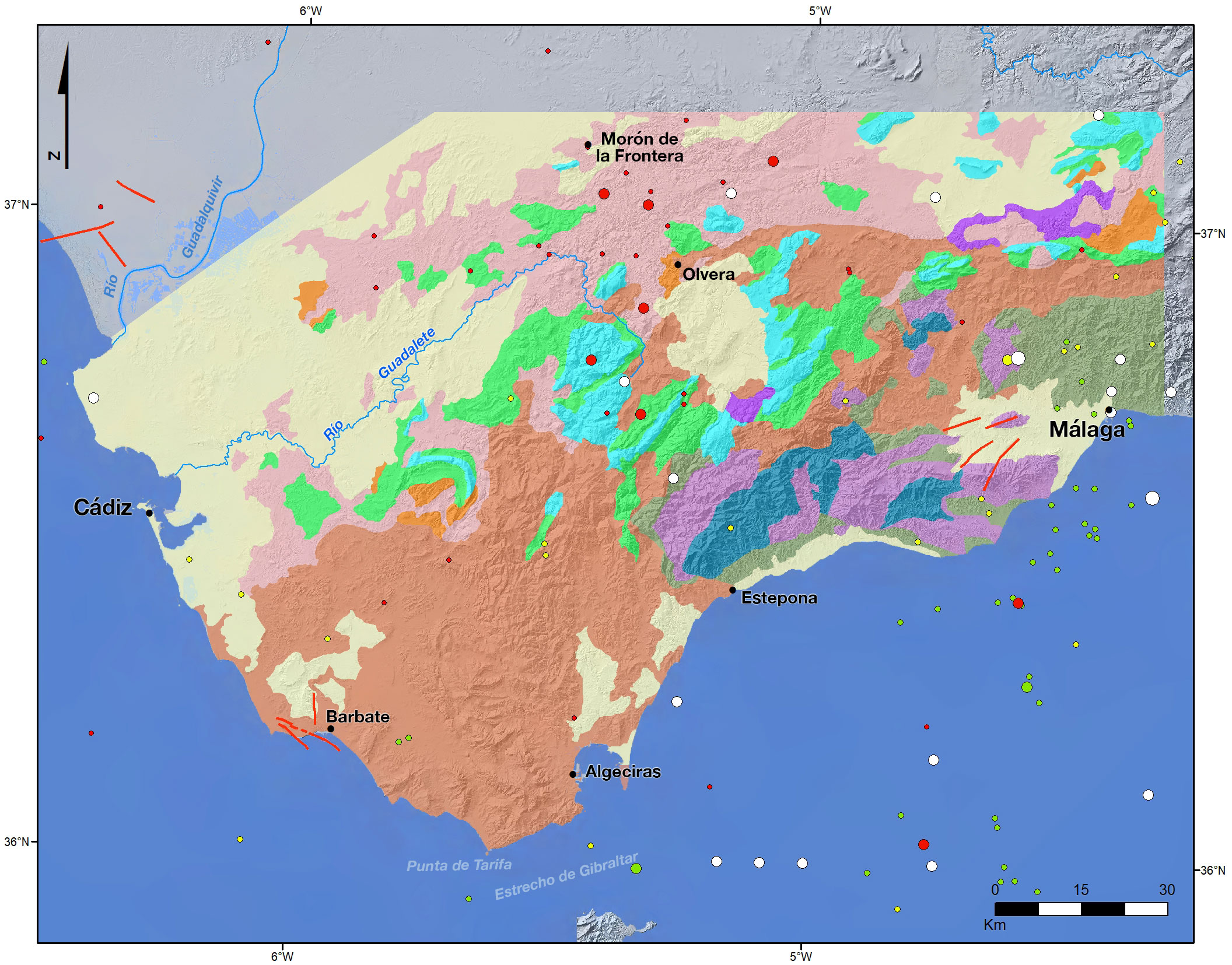
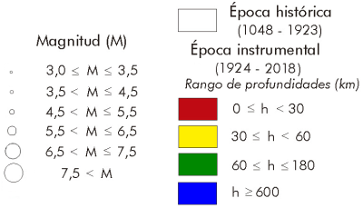
The seismicity in this area is of lesser magnitude and occurs less frequently than in the central and eastern sectors of the Béticas. Earthquakes occur near the mountain front and show a mixture of inverse and tearing mechanisms. It is characterized by low and moderate magnitudes and surface earthquakes, although some occur under the crust. Much of the seismicity is concentrated in seismic series such as those registered in Morón de la Frontera from 2007 to 2009 or between La Puebla de Cazalla and Olvera in 2019, Teba in 2006 or Espejo (Córdoba) where an earthquake of M5.1 was registered in 1985, close to the earthquake of M5.1 in Montilla in 1930. During the historical period, important earthquakes of VIII-IX intensity have occurred in the Guadalquivir basin (1504 in Carmona, Seville, where most of the buildings cracked or fell and 32 people died), and in the Malaga basin (1680 NW of Malaga, an earthquake that, although there is some controversy about it, may have generated a tsunami). In addition, there is a significant group of earthquakes of intermediate depth (40-120 km), whose epicentres are aligned with a NNE-SSO direction from Malaga to the coast of Morocco by the Alboran Sea. An example of these earthquakes is the one that occurred in 1976 to the northwest of Malaga from M5.5 to 54 km deep.
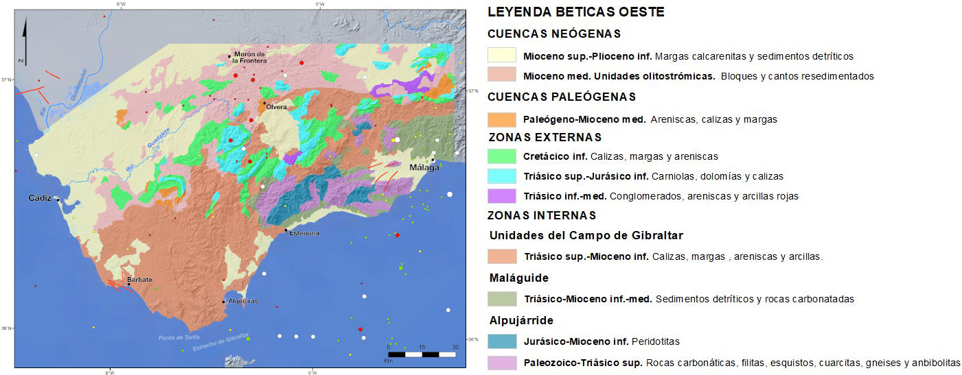
The area extends from Malaga to the mouth of the Guadalquivir River and forms the northern part of the arch of Gibraltar. In the southern third of the area outcrop domains of the Internal areas, the Maláguide, represented in the mountains of Malaga, and the Alpujárride with units from the Palaeozoic to the upper Triassic. In the Málaga basin there is a diffuse tectonic deformation and the most western outcrops of the Internal Baetic areas, limited by the Gaucín fault. Associated with the Alpujarra units are large peridotitic masses of Jurassic-Lower Miocene age which form extensive outcrops in Sierra Bermeja, Sierra Alpujata and Sierra Aguas, as well as other minor outcrops in Sierra de Mijas and Sierra de Cártama. The metamorphic rocks associated with peridotites outcrop mainly in the Sierra de Ronda.
The Campo de Gibraltar Complex outcrops extensively in the part of Gibraltar-Barbate towards the north and its surroundings towards Málaga. It is an allochthonous Cretaceous-Tertiary succession of the continental crust of the Betic flysch. It is structurally located on the External Areas and is covered by the Internal Areas. They are deposits that were dragged as an accretion prism between the Iberian and Alboran plates that moved to the margins to emerge later on the surface, in structures of riding plates as we see them today. The most accentuated reliefs form the curvature of the Gibraltar arch.
The upper third is occupied by the western Baetic foothills of the Outer areas with Triassic, Jurassic and Cretaceous outcrops without a clear structural continuity which, towards the north, are surrounded by the allochthonous or olithochthonous units of the Middle Miocene.
Structurally, in the Internal Baetica section, in addition to the deformation in the Málaga basin area, the Torcal shear area in the innermost part of the external areas is noteworthy, and has been active since the upper Miocene.
In Western Baetica the deformation is distributed between a parallel stretch to the Baetica and a shortening in an approximately perpendicular direction. The extension is located in areas with normal faults such as the Ronda basin, the normal fault zone of Ubrique and towards the south of the province of Cadiz. However, many of the active faults in this sector are not known to have no surface expression.
The compressive regime extracted from tectonic and seismic data is compatible with compression in the NW-SE direction consistent with GPS data. This indicates that, unlike what happens in the rest of the Béticas, the Eurasian-Nubian convergence materializes in surface earthquakes of inverse mechanism.
| © Instituto Geográfico Nacional - C/ General Ibáñez de Ibero, 3. 28003 Madrid - España.
ign@fomento.es |


