
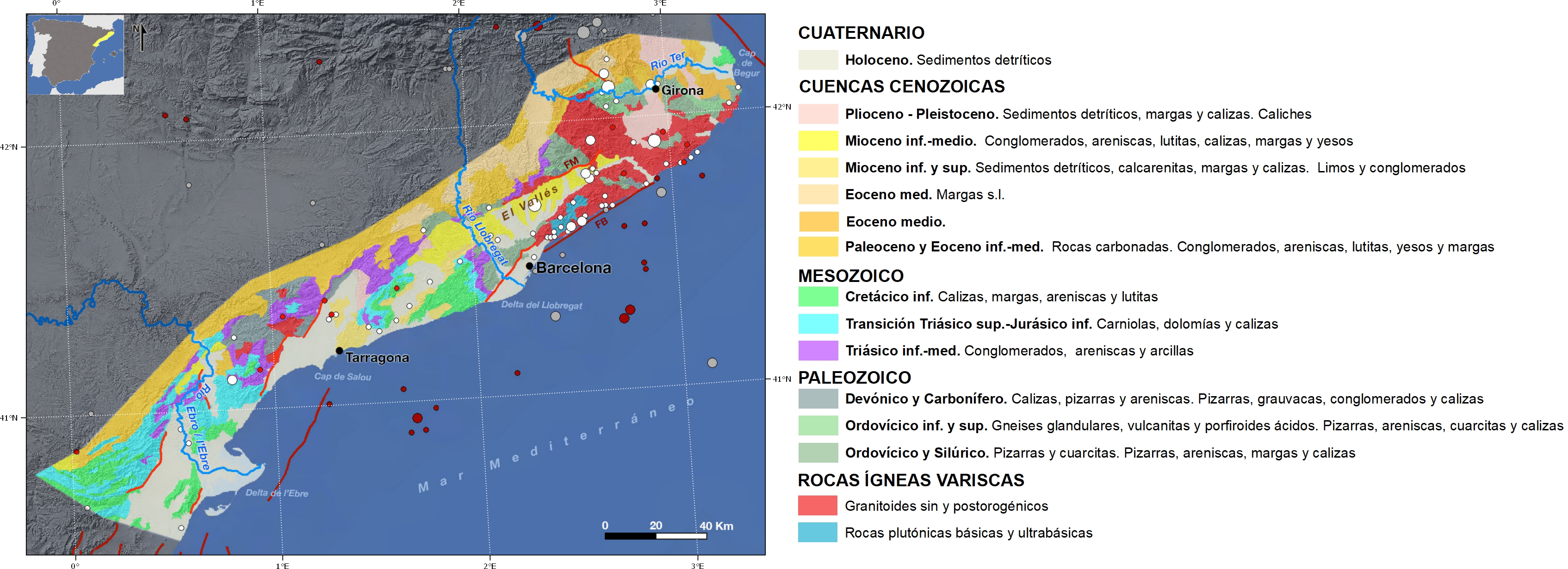
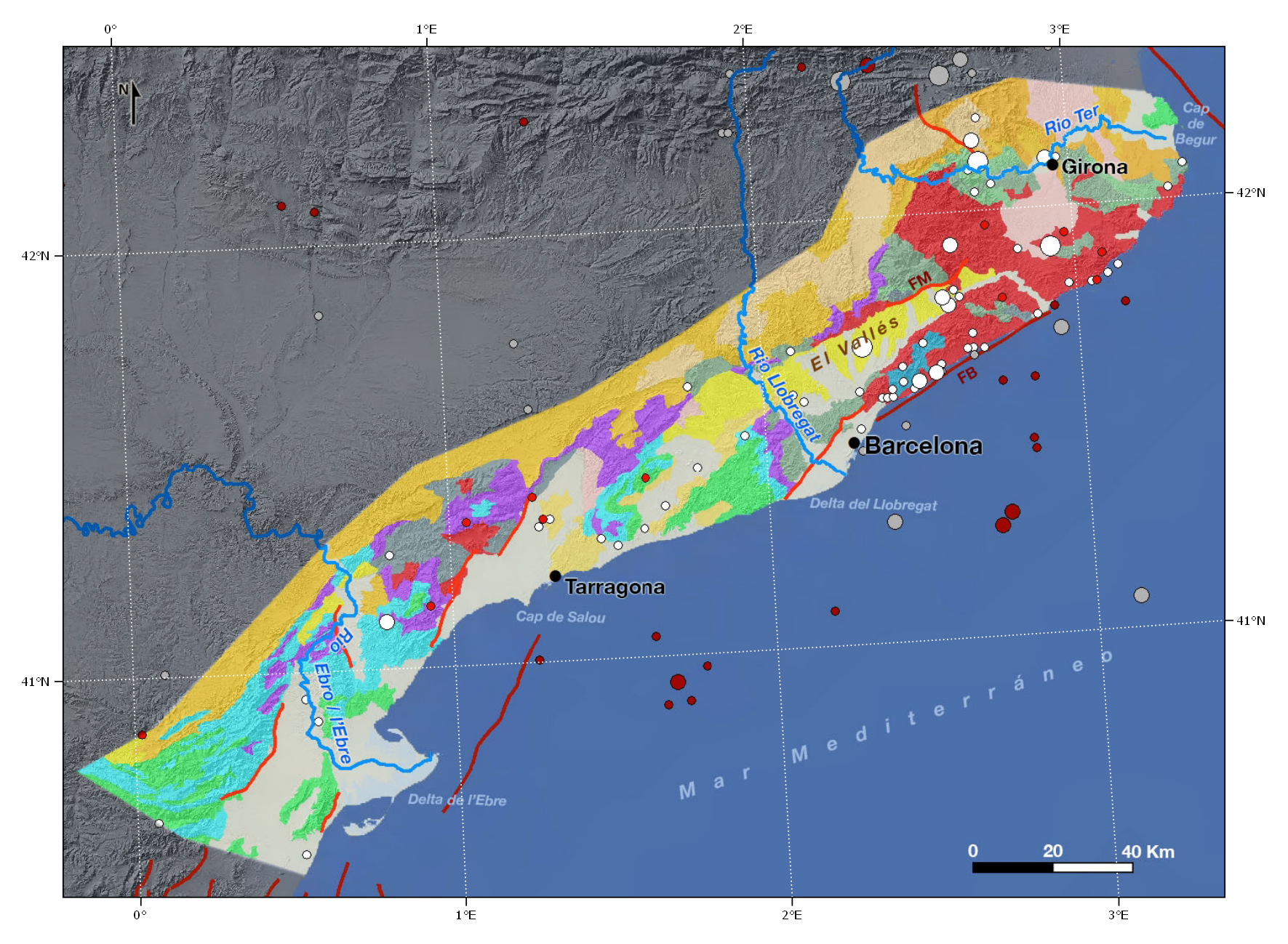
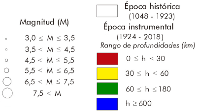
The seismicity of this region can be considered between low and moderate. In the catalogue of historical earthquakes the seismicity is concentrated in the northern part, around what is known as the Transversal mountain range, highlighting the Amer (Girona) seismic series between March and June 1427 attributed to the Amer fault. From this series there is information of at least five earthquakes with greater intensity than VII, reaching one of them the intensity VIII.
The earthquakes of 1427 in Caldes de Malavella (Girona), 1448 in Cardedeu (Barcelona) and 1927 in San Celoni (Barcelona) are somewhat less intense.
In more recent times, there is no record of earthquakes exceeding a magnitude of 5.0 in this area. Among the largest earthquakes in instrumental epoch we can point out the 1943 of M4.5 in Blanes (Girona) and those occurred in the Mediterranean Sea with magnitude around 5.0 in 1958, 1972 and 1995.
The Coastal-Catalan and Iberian mountain ranges are two large intraplate alpine structures that constitute two tectonic domains of similar age and style, moderate deformation, very little alpine schistosity and absence of metamorphism except in very specific places. For all these reasons, the group is called the Iberian Chain. Both mountain ranges have a base varisco continuation of the Iberian Massif.
The passage from the Iberian Mountain Range to the Catalan Coastal Range is made through the so-called Link Zone where the Iberian structures (NW-SE) and the Catalan coastal structures (NE-SO) interfere, whose expression in its northern part is a tectonic arch called the Montalban Arch.
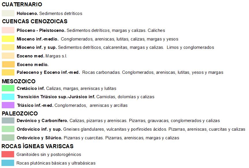
The Coastal-Catalan mountain range forms a mountainous barrier that closes off the Tertiary Basin of the Ebro river. It extends in a NE-SO direction, parallel to the Mediterranean coast, from the Pyrenees (Bay of Roses) to the Ebro delta, with a length of about 250 km and about 40 km wide. It is made up of two mountainous alignments parallel to the coast, one close to the sea, called Cadena Litoral, of low altitude (heights around 600 m) and hidden under the sea in the area of Tarragona, and another more inland, called Prelitoral, where are the highest mountains (Pico Montseny, 1,712 m). In its southern half there are some massifs formed by consolidated conglomerates resistant to erosion - among them are Montserrat and Montsant, which are over 1,000 m above sea level. Both chains are separated by several tectonic pits. Their current structure is due to the superposition of compressive processes during the Paleogene, and distensives in the Miocene.
The materials that make up the mountain range are grouped into two totally different levels: a base or varicose base, with pre-Cambrian and Paleozoic rocks, but the powerful sedimentary series of the upper Permian and, above all, of the Mesozoic and discordant Cenozoic formed by the filling of the basins originated in the rifting processes that affected Iberia during the opening of the Tetis stand out. The first contains metamorphic materials from the Cambrian, Ordovician and Middle Carboniferous ages, very similar to those found in the axial zone of the Pyrenees. Intruding into these Paleozoic materials are granite massifs s.l. which represent 60% of the entire basement.
The Mesozoic cover emerges mainly in the southern half of the mountain range and is formed by its three main systems: Triassic, Jurassic and Cretaceous, the latter being the dominant.
The Neogene basins were generated during the distant Miocene period of the chain and form a series of tectonic pits (El Valles, El Penedes and the Campo de Tarragona) that are filled with loose detritic sediments. The Valles-Penedes depression is a tectonic fossa or graben formed 30 years ago. In the same period and by means of the same mechanism, the coastal pits between Barcelona and Valencia were also formed. These tectonic graves are associated with vulcanism and thermal activities, as in Hostalric, and whose thermalism continues today, and is linked to the structure and disposition of the faults that limit depression.
| © Instituto Geográfico Nacional - C/ General Ibáñez de Ibero, 3. 28003 Madrid - España.
ign@fomento.es |


