
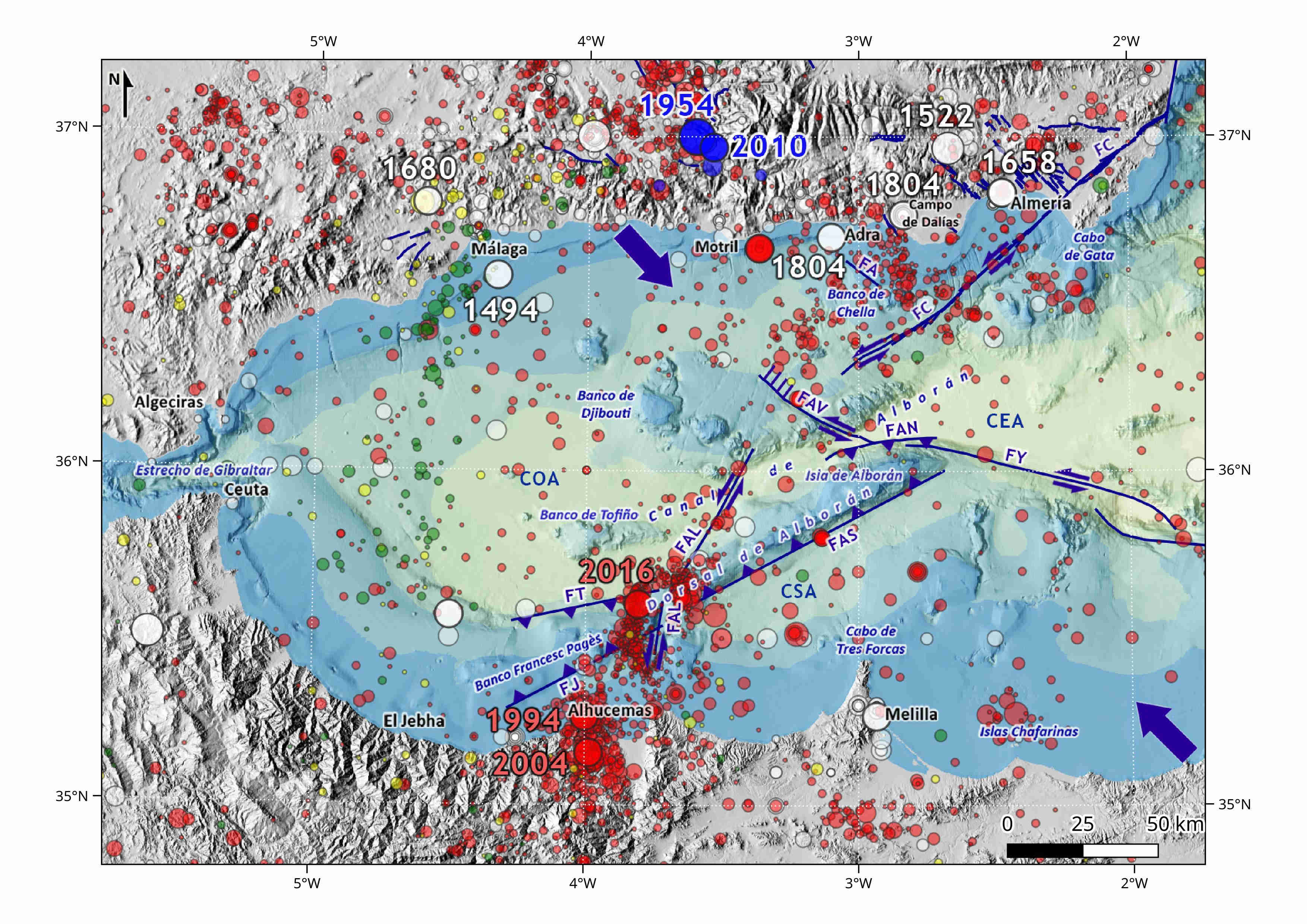
Historically there have been significant earthquakes in the North of the Alboran Sea, as the 1522 earthquake with 1,000 casualties, and the fall of most of the houses of Almeria and Ugíjar (Granada), or the 1680 earthquake that caused 70 casualties and the destruction of 20% of the houses in Málaga. In the last 100 years a large number of shallow earthquakes have been detected, mainly in the northwest of the Carboneras (FC) fault, in Al Idrisi (FAL) fault and in Alhucemas region, like for example the M 6.2 earthquake in 2004 which caused 600 casualties in Morocco and the M 6.3 earthquake in 2016, a little further to the north. The existence of a significant number of intermediate-depth earthquakes (40-120 km), whose epicenters are aligned with a NNE-SSW direction from Málaga to Morocco coast, and of others deeper than 600 km that occur sporadically inland in the South of Granada as the M 7.1 earthquake in 1954 and the M 6.2 earthquake in 2010, has given rise to various theories on which there is still no unanimous agreement. Some of the most accepted theories are the existence of a subduction of the Atlantic oceanic lithosphere under the Gibraltar arch, with a dip towards the east that becomes almost vertical in depth, or the occurrence of various delamination processes under the Alboran Sea.
The Alboran Sea is located between the Betic mountain range and the Rif. They form together what is known as the Gibraltar Arch, an Alpine orogen in the westernmost part of the Mediterranean Sea. This system was formed in the lower Miocene by migration of the Alboran microplate to the west, which collided with the Iberian plate tangentially in the context of the NW-SE convergence between the African and Eurasian plates. This scenario gave rise to a simultaneous cortical compression and extension generating the surrounding mountain chains and the Alboran basin, respectively. The extension in the Alboran sea produced a thinning of the continental crust and magmatism and volcanism in the upper Miocene, so that the seafloor have a rough and complex relief, with sub-basins separated by underwater elevations and volcanic cones. The extensive stage ceased in the upper Tortonian, giving rise to a predominant compressive regime, accommodated by perpendicular to compression by aligned folds and reverse and strike-slip faults with orientations NNE-SSW and WNW-ESE.
Under the Alboran Sea lies a 15-20 km thin continental crust formed by alpine metamorphic rocks over a Variscan basement. The Neogene and Quaternary cover comprises lower Miocene sedimentary rocks and Tortonian basic and intermediate volcanic layers.Seafloor average depths is about 1,000 m, reaching 2,000 m in the eastern region
Currently, convergence between Eurasia and Africa in the region has a NW-SE direction with a motion rate of 5 mm/year. Among tectonic structures highlight Alboran Ridge and Francesc Pagès Seamount, about 100 and 20 km long submarine ridges respectively, with NE-SW orientation and bounded by reverse faults with opposite dip to the North and to the South; and on the other hand, two sets of conjugated directional faults: the left-lateral faults with NNE-SSO direction as Al-Idrisi fault (FAL) or with NE-SW direction as Carboneras fault (FC); And the right-lateral faults with WNW-ESE direction, as the Yusuf fault (FY), consisting of two 100-km-long segments. Part of the Alboran Ridge was an active volcano during the upper Miocene. In this elevation, Alboran Island is the only outcrop in the sea surface, divides the Alboran Sea into three sub-basins: West, East and South.
| © Instituto Geográfico Nacional - C/ General Ibáñez de Ibero, 3. 28003 Madrid - España.
ign@fomento.es |


