
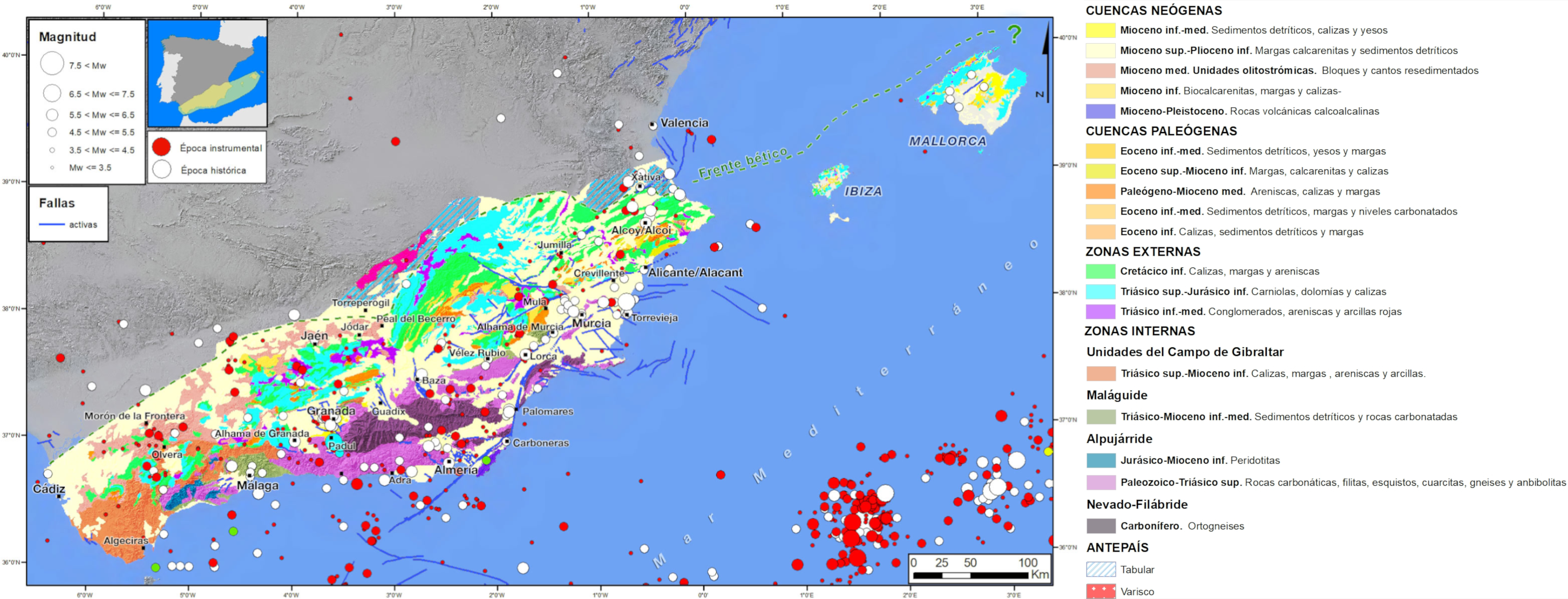
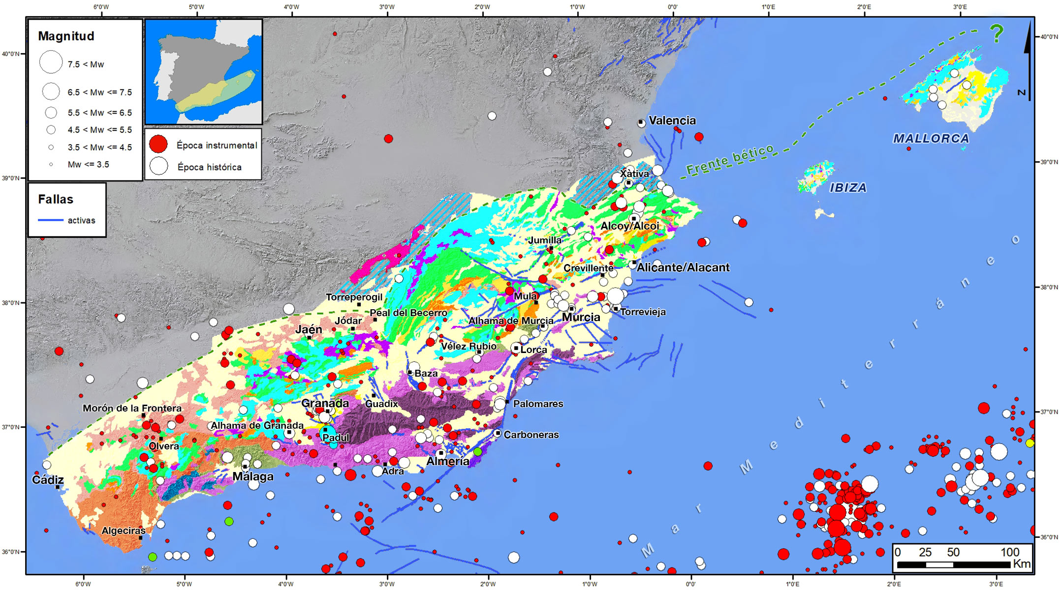
The Betic mountain ranges constitute the region with the highest seismic activity in the Iberian Peninsula; there are many low to moderate magnitude surface earthquakes. There is also a certain seismicity at intermediate depths that extends into the western part of the Alboran Sea and, occasionally, earthquakes at depths of more than 600 km with the epicentre in the province of Granada. In pre-instrumental times, great earthquakes have occurred, such as the two IX-X earthquakes in 1829 in Torrevieja and, in 1884, in Arenas del Rey, with an estimated magnitude of around 6.5. However, in the instrumental period the largest surface earthquakes have been of magnitudes around 5.0 as in 1919 in Jacarilla (Alicante), 1930 in Montilla (Córdoba), 1956 in Purchil (Granada) and 2011 in Lorca (Murcia). The largest earthquakes of the instrumental period have been those of a deep type, such as the Granada earthquakes of M7.8 in 1954 and M6.3 in 2010.
Together with the Rif Mountains in North Africa, the Betic Mountains form the most western segment of the Mediterranean alpine orogen. These two mountain ranges are separated by the Neogene Alboran basin and form the most closed orogenic arch (Gibraltar arch) of the Alpine orogens. It began to form in the Miocene, as a result of the NW-SE convergence between the African and Eurasian plates and the westward thrust of the Alboran plate. Currently this orogen is located at the diffuse boundary between the African and Eurasian plates which are approaching in a WNW-ESE direction at about 5 mm/year.
They constitute all the mountainous reliefs found in the south of the Iberian Peninsula, which extend from the Gulf of Cadiz to the coast of Alicante and the Balearic Islands. They have a length of about 620 km with their maximum altitude at the Mulhacén peak of 3,478 m. It was raised during the Alpine orogeny. It is affected by a NW-SE compression (approach vector of 4.5 mm/year near Gibraltar) to NNO-SSE along with another NE-SW to ENE-OSO extensional stress direction. The structures generated by the approach are compressive, dipping faults and ripping faults associated with N-S shortening. The Neogene opening of the Valencia Furrow has imposed an extensive character on the eastern part of the peninsula. The alpine compressive deformation has a shortening rate between 10 and 20%. They have the Guadalquivir valley and the Iberian massif as their forerunners.
The mountain range is structurally divided into two areas: External Areas, subdivided into the Pre-Baetic domain, which outcrops to the north mainly in the eastern part, and the Sub-Baetic domain, which rides on the Pre-Baetic to the east of Jaén, and which is formed by Mesozoic rocks (mainly carbonate rocks), and Cenozoic rocks that are ridden and folded without the presence of metamorphism.
Outlying in the External zone, and not linked to the Pre-Baetic-Subaetic division, the Olistrostomic or Allochthonous Unit extends from the Gulf of Cadiz to Alicante. It is a megabreccia with an age of 15-13 Ma with a chaotic structure. It has blocks of varied elements from the Mesozoic-Paleogene series of the External zone with a very plastic matrix and low competition. The pelitic-yesiferous triassic sediments created take-off levels under the Jurassic-Cretaceous and Cenozoic units in the early stages of compression and facilitated the allochthonous character of the cover. There are from sands to large hectometric blocks structured chaotically. The matrix are pelitic-yesiferous sediments with other marlysiferous ones that facilitate mobility through dense flows. In some boreholes in the coastal province of Cadiz, the boreholes have cut up to 1,500 m thick, although most often the power fluctuates between 1,000 m and 200-300 m.
The Internal Zones collide obliquely with the External Zones during the Miocene. They occupy the southernmost position of the mountain range bordering the Alboran Sea. They extend from Estepona (Málaga) in the west to Cape Santa Pola, between Murcia and Alicante, in the east. They are divided into three domains that rode on top of each other but were later transformed into extensional take-off faults. From top to bottom are the Maláguide, Alpujárride and Nevado Filábride complexes. They are composed of essentially metamorphic materials, with a plurifacial alpine metamorphism, whose origin is related to the migration of the Alboran micro plate, located further east. All areas are composed of numerous allochthonous units whose degree of allochthony decreases towards the north. Between the External and Internal zones there was a strip of oceanic crust on which Cretaceous and Paleogene materials were deposited, mostly originated by turbidity currents -flysch- in the marine environment. They currently constitute the Campo de Gibraltar complex, a set of superimposed shifting mantle and scales completely uprooted from the Cretaceous and Paleogene in the area of the Strait of Gibraltar and its surroundings.
Although originally all the depressed areas within the mountains were flooded by the sea, gradually, as the mountain range rose, the sea withdrew and some of them became endorheic basins where rivers flowed and important lakes were formed. Thus, we can group these basins according to the predominant type of sedimentation that emerges: marine or continental. They are depressions filled with Neogene and Quaternary sediments (sometimes hundreds of metres in depth), the product of the erosion of the surrounding reliefs with a subsident regime, many of them limited by active faults, more or less closed and separated from each other (Ronda, Antequera, Granada, Guadix-Baza, Huéscar, Almería-Sorbas, Vera-Cuevas de Almanzora and Bajo Segura, etc.) which are interspersed between the External and Internal areas.
Geodynamically, the Béticas are currently subjected to compressive stress in a NW-SE to NNO-SSE direction together with extension in a NE-SW to ENE-OSO direction, both accommodated by folds and active faults. Deformation in these mountain ranges varies from east to west. In the eastern part, the NW-SSE convergence prevails with associated active structures that accommodate that shortening, while towards the west displacements towards the W and SW are observed with respect to the stable part of Iberia, presenting a complex deformation pattern that includes extensive, transcendent and compressive structures.
| © Instituto Geográfico Nacional - C/ General Ibáñez de Ibero, 3. 28003 Madrid - España.
ign@fomento.es |


