
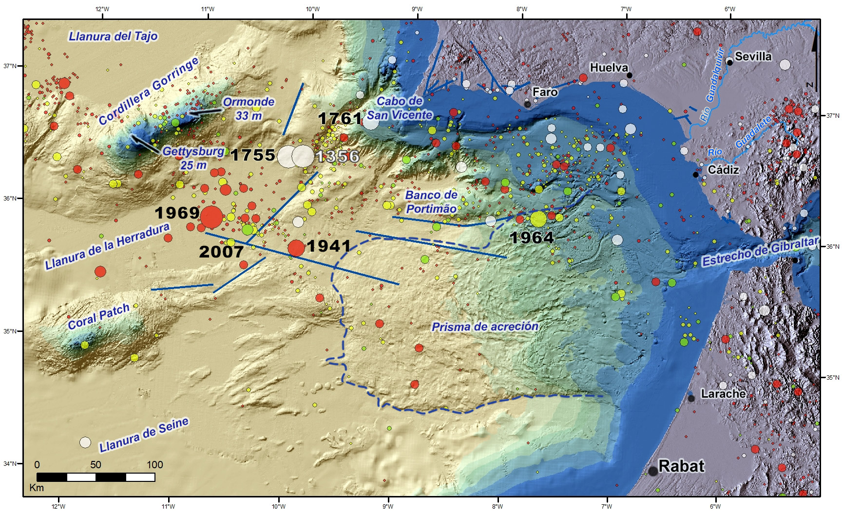
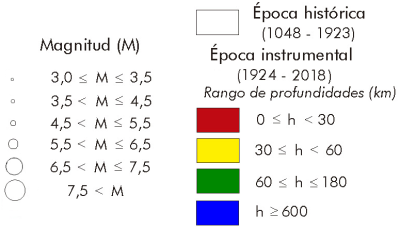
In the area to the southwest of Cape St. Vincent, the largest earthquakes have occurred, of which we are aware, in the area surrounding the Iberian Peninsula. The main one is the 1755 earthquake, with an approximate magnitude of M8.5, in the direction of Western Europe and North Africa and with a maximum intensity of X in the south of Portugal. This earthquake generated a tsunami with waves that reached heights of 10-15 meters in the Gulf of Cadiz and in total it is estimated that caused some 15,000 victims. In addition to this earthquake, in the same area, and within the historical period, the 1356 and 1761 earthquakes stand out, the latter also in different areas of Europe and which caused a tsunami that reached the coasts of Portugal, Spain, Great Britain and even Barbados, although with much less severity than the 1755 earthquake. Already in the instrumental period the most important earthquake in this area was that of 1969 of M7.8 producing intensities VIII-IX and VIII in several locations in southern Portugal and a small tsunami on the coasts of Morocco, Portugal and Spain. It is also worth mentioning the 1941 earthquake of M6.7 and more recently those of 2007 and 2009 of M6.1 and M5.7 respectively.
In the actual area of the Gulf of Cadiz, earthquakes have occurred such as that of 1722 in Tavira (Portugal), which devastated several towns in southern Portugal, where it reached intensity VIII, and caused a local tsunami that flooded shallow areas of Tavira and further south that of 1773, perceived with a maximum intensity of VII. Already in the instrumental period, an earthquake of M6.6 was recorded in 1964, which was also perceived with intensity VII.
Throughout this area there is no clear alignment of the epicentres, suggesting that the contact between the African and Eurasian plates is reflected in a network of faults distributed in an E-W band about 100-150 km wide parallel to the coast of southern Portugal.
Most of the focal mechanisms in this area are of the inverse and tearing type with a maximum horizontal compression in the NW-SE direction.
It has been observed that the depth of the earthquakes reaches in some cases 50-60 km although without clearly marking a subduction zone. This could be explained as the behavior of an old and cold oceanic lithosphere that presents fragile behavior up to the upper mantle.
Since the beginning of the formation of the Orogenic Arc of Gibraltar, the Gulf of Cadiz has been located on the border of the Eurasian and African plates, characterized by a regime of oblique convergence NW-SE. It is limited by the Iberian massif and the Algarve basin to the north and, in the eastern part, by the orogenic arch of the Betic-Rifian mountain range, the westernmost of the Mediterranean alpine chains.
The Gulf of Cadiz accommodates the existing compressive regime between Europe and Africa, which produces a significant seismicity. There is a transition zone of continental-oceanic crust still not very well defined.
The structure of the continental margin of the Gulf of Cadiz is controlled mainly by the formation of the Betic-Rhine Orogen and by post-orogenic tectonic activity.
Most of the Gulf of Cadiz is located on thinned Iberian or African continental crust that thins towards the west, while the oceanic crust is found under the abyssal plains of the Herradura, Seine and the adjacent seamounts: Gorringe, Ampere and Coral Patch. Some of the geological structures in this area can produce earthquakes and, consequently, tsunamis.
On the ocean floor, there are a multitude of underwater reliefs (seamounts), most of which correspond to extinct volcanoes that did not emerge from the abyssal plains, such as those of the Tagus, the Horseshoe and the Seine. Of all the reliefs, the Gorringe mountain range stands out for its size. It rises 5 km from the abyssal plain of La Herradura and runs in a NE-SW direction, 200 km long and 70 km wide, with two small seamounts at the top: Gettysburg, at 25 m, and Ormonde at 33 m. This relief is formed by oceanic crust gabbros, serpentine rocks and alkaline basalts.
The tectonic activity in the Gulf of Cadiz is related to the limit of the tectonic plates between Eurasia and Africa. The great fracture of the Azores, heading towards Gibraltar, reaches the Gorringe mountain range directly. In its extension towards the east it is difficult to establish a unique fracture zone, being quite diffused in several parallel fractures that are considered the limit of the plates.
In the eastern part of the gulf, the "accretion prism" or "allochthonous unit", the main geological feature of the gulf, stands out. The northern boundary of this structure has a displacement towards the west of 1.8 ±0.8 mm/year. It has a sedimentary cover of medium Miocene age at present, of 3,000 m of power.
The deformation is not only controlled by regional efforts but also by the large amount of clayey and saline diapirs (from the Triassic facies) as well as muddy volcanoes located at depths between 300 and 1,200 m, located on the upper and middle continental slope of the Suribérico continental margin. They are reliefs of preferably conical geometry, which are formed as a result of the process of expulsion of gas-laden fluids from the sea floor. The clayey diapir bodies are a chaotic seismic facies in contact with the sedimentary cover.
In the frontal area of the Bay of Cadiz, and within the "accretion prism", there is a set of normal faults (sometimes listric) dipping to the west that have a NW-SSE direction that turns to N-S in the southern part. Some are active faults as they cut the sediments down to the sea floor.
| © Instituto Geográfico Nacional - C/ General Ibáñez de Ibero, 3. 28003 Madrid - España.
ign@fomento.es |


