
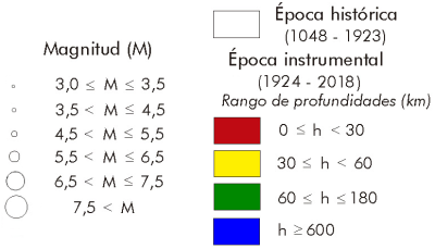
The historical and instrumental seismicity in this intra-plate mountain range is low except in its southeastern foothills, already in contact with the northeastern part of the Baetic mountain ranges, where there are important historical earthquakes catalogued that reach an intensity of IX in the province of Valencia such as that of 1396 in Tavernes de Valldigna and that of 1748 in Estubeny,
although no significant earthquakes have been recorded in the last 100 years, with the 1914 in Villanueva de Castellón and 1938 in Enguera of magnitudes slightly less than 5.0 being the largest.
In the rest of the Iberian mountain range we can highlight the earthquakes that occurred in the northeastern part, in La Rioja, such as that of 1817 in Prejano of maximum intensity of VII-VIII and 1929 in Turruncún of M5.2 and more to the south, and in the province of Zaragoza in 1912 in Zimballa of intensity VI-VII and 1953 in Used of M4.8. The areas of the Teruel and Jiloca graben, with active faults where important earthquakes have been studied in geological epochs do not have significant events in the catalogue of historical earthquakes.
In cases where it has been possible to study the nature of their earthquakes, this corresponds to an extensive regime in line with the influence in this area has the extension in the furrow of Valencia.
The Ibérica and Costero-Catalana mountain ranges are two large alpine structures partially eroded, which form two tectonic units of similar age and style, which is why it is known as the Iberian Chain.
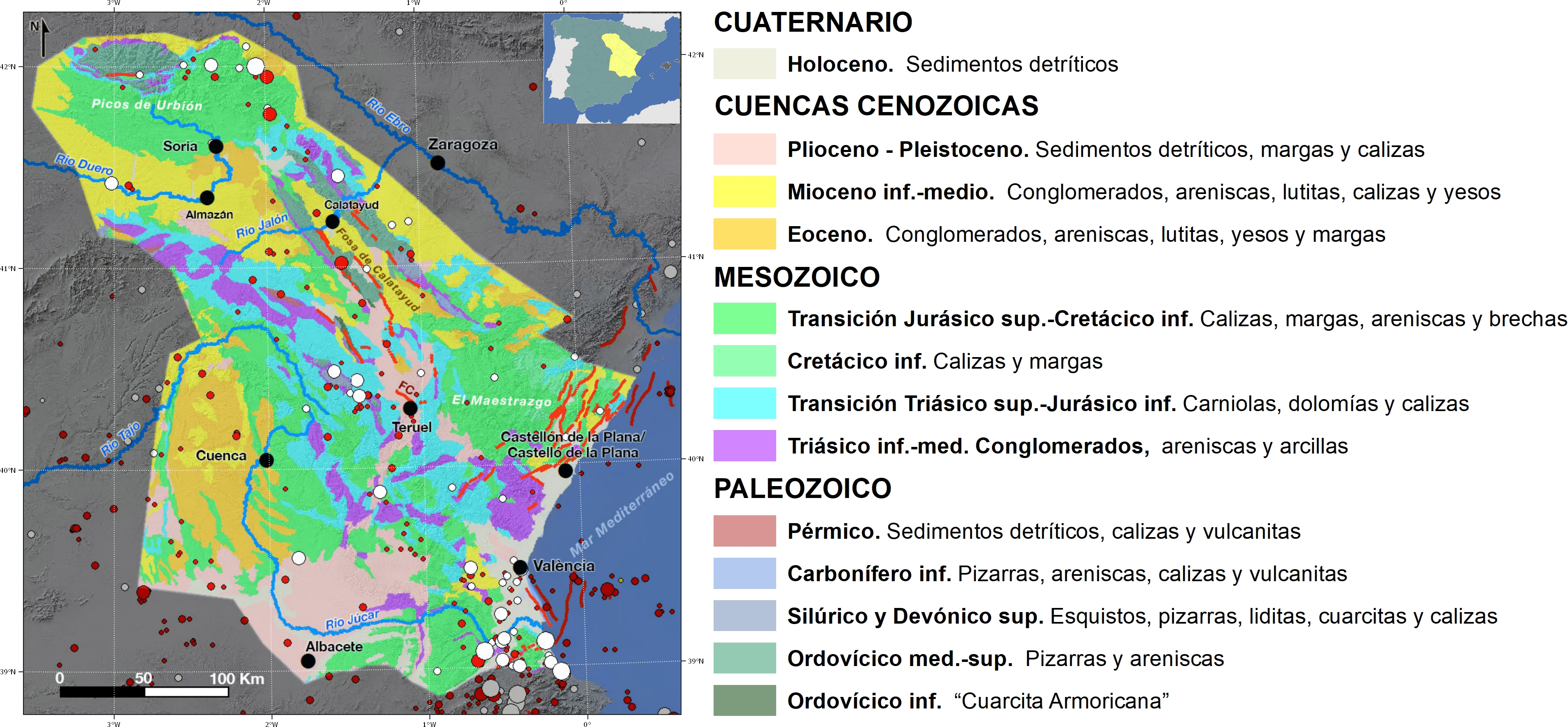
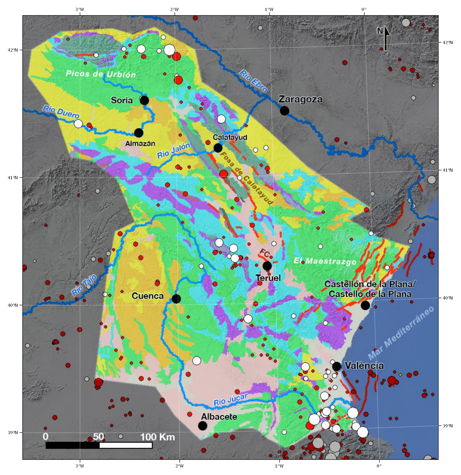
The Iberian mountain range is an alpine chain within the plate, of general direction NW-SE and double vergence. It is just over 400 km long, an average width of 100 km and stretches from La Bureba (Burgos region) to the Mediterranean coast of Valencia. It is organized by a series of NW-SE mountain alignments that link up with the Catalanides at their eastern and southern extremes, through El Maestrazgo.
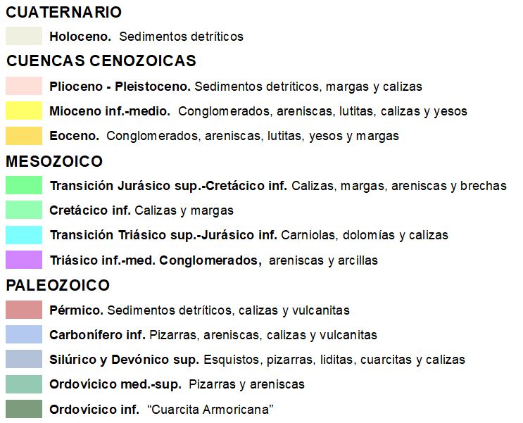
In the Iberian mountain range two branches are distinguished, the Aragonese and the Castilian, separated by the tertiary basin of Almazán. The Aragonese branch is in turn divided into two parallel alignments separated by the Calatayud basin. The stratigraphic record goes from the Precambrian (very scarce) and Paleozoic to the Quaternary, but the most representative is the great Mesozoic cover (Triassic, Jurassic and Cretaceous), which is arranged discordantly on a pre-Permic base. The materials that form the mountain range are fundamentally Mesozoic limestones that reach up to 5 km of power (Cameros Unit) and detritic sediments from several Neogene basins. Locally, materials from the Paleozoic socle emerge in the nuclei of some anticlines, which were covered by Mesozoic materials and which have been exhumed in the alpine folding. Thus, the most important emerge in the Sierra de La Demanda and in the elongated nuclei of the Aragonese branch. The Mesozoic register is clearly conditioned by extensional tectonics, identifying two preferential orientations of normal faults (NO-SE and NE-SO)
The main characteristics are: almost total absence of deep Mesozoic and Cenozoic facies sediments, predominantly shallow platform and transitional environments over lake and alluvial sediments; moderate general deformation, with very little alpine schistosity and almost total lack of metamorphism; and finally, a marked contrast between the structural style of the base and that of the Mesozoic cover.
The Iberian mountain range has neither the continuity nor the orogenic thrust of the reliefs of the Pyrenean and Baetic mountain ranges for which it is the foreland of folding. It represents the rim of the plateau fractured, folded and erect due to the compressive pressures suffered from the Pyrenean-Cantabrian and Baetic-Balearic nuclei, hence its curvature from the Maestrazgo knot. It was an area that registered an important differential subsidence associated to different stages of rifting, so that during the stage of cenozoic shortening the Mesozoic basins are inverted. In the Iberian mountain range it is the extension of the Cretaceous that produces a greater imprint in the subsequent compressive deformation.
The compressive structure of the chain is characterised by a main direction of NW-SE or Iberian folds, tears and dipping, to which a second family of E-W to ENE-OSO transverse folds and dipping is superimposed, especially in the centre-east.
The mountain range is fragmented into several blocks, whose maximum heights rarely exceed 2,000 m, and in which different zones are distinguished: the Cameros Unit, the Aragonese branch, the Castellana branch and the Altomira mountain range at the western limit of the same. Its general geological structure should include, among others, the large Cenozoic basins of Calatayud-Montalbán, Almazán (in connection with the Duero Basin), Teruel and Jiloca. In the latter it is necessary to emphasize the normal active fault of Concud (14, 2 km long) that limits the engraving in the SE.
On the other hand, in the intramontanous tertiary basins, the deposit of Cenozoic syntectonic materials in these basins in alluvial fan environments took place during the Paleogene.
The degree of deformation of the Iberian mountain range is moderate, with very little alpine schistosity and little metamorphism. Its structure was mainly formed about 25 Ma, in the Oligocene, during the alpine orogeny, and consists of a set of folds, with a NW-SE orientation, which mainly affect the rocks of the cover, although towards the SE this orientation becomes EW. In particular, the NE-SO compression, transmitted from the edge of the Pyrenees, was the most intense and the one that originated the most important structures of the Iberian System.
In the SE zone of the mountain range there are active faults linked to the Neogene Quaternary extensional deformation of the rifting of the Gulf of Valencia basin. The result of this field of efforts are the Teruel and Jiloca graben.
| © Instituto Geográfico Nacional - C/ General Ibáñez de Ibero, 3. 28003 Madrid - España.
ign@fomento.es |


