
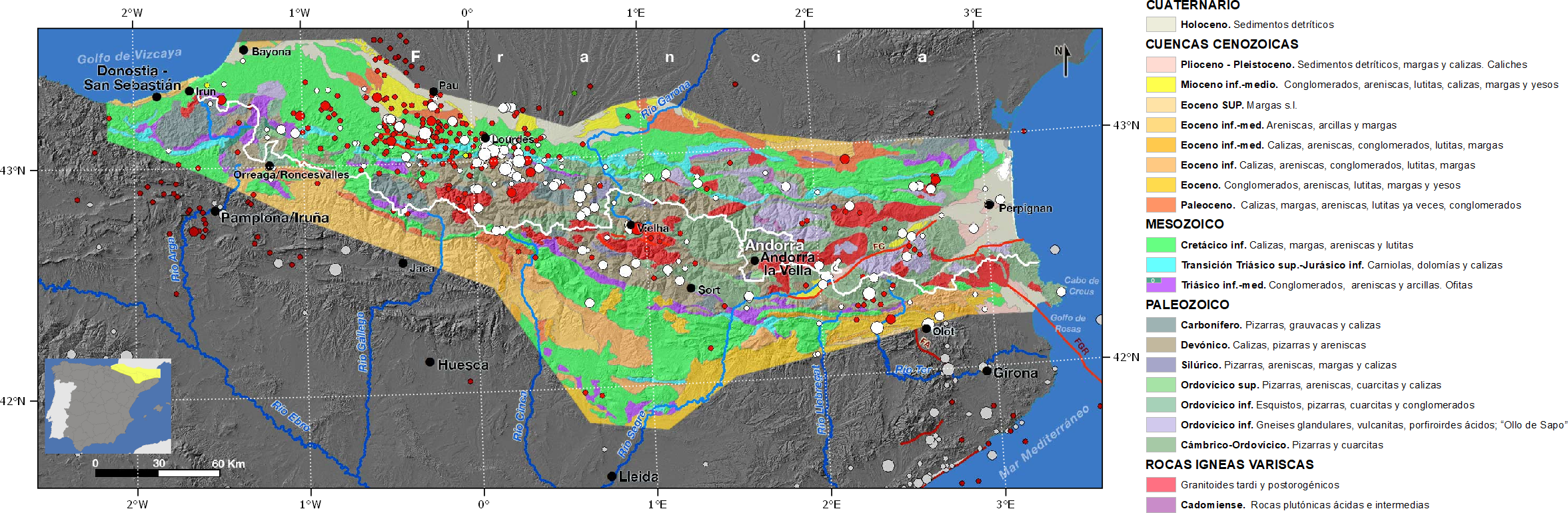
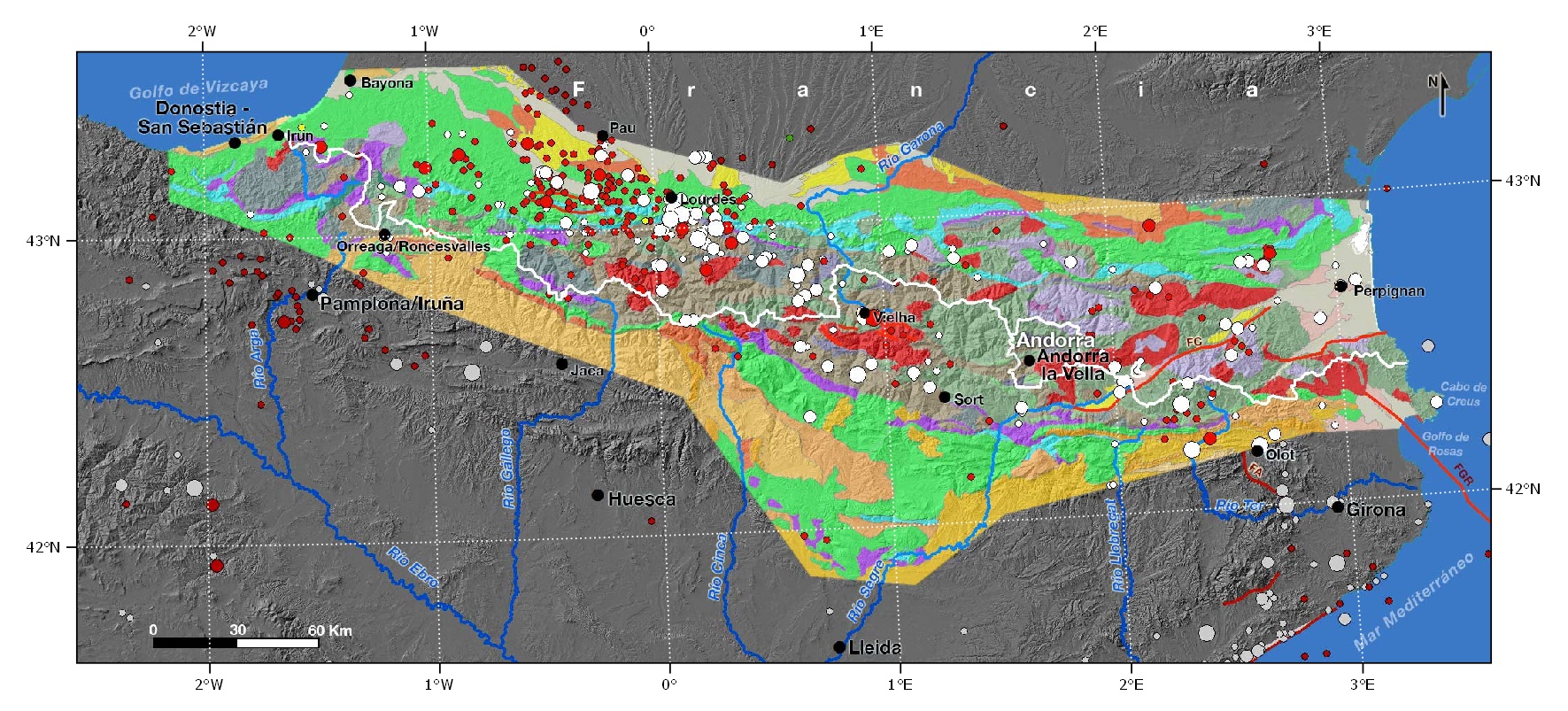
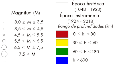
The Pyrenean mountain range has a moderate seismicity. However, the catalogue of historical earthquakes includes the IX-X earthquake that occurred in 1428 in Queralbs (Girona), which caused the destruction of the city and some 800 victims, as well as three earthquakes of VIII-IX intensity: 1373 in Ribagorça (Lleida), 1427 in Olot (Girona) and 1660 in the French department of Altos Pirineos, where other important historical earthquakes have also occurred, such as that of VIII intensity in 1750. Further west, some smaller earthquakes have taken place in the department of the Atlantic Pyrenees (France), the largest of these being that of VII-VIII intensity in 1814..
In the instrumental period, for approximately 100 years, the seismicity registered has been between low and moderate, although two earthquakes stand out in 1923 in the Berdún Channel (Huesca-Zaragoza), south of the Pyrenees, of intensity VII and M5.4 and in the Aran Valley (Lleida) of intensity VIII and around M5.6, in addition to two earthquakes of M5.1 occurred in 1967 and 1980 in the High Pyrenees (France) of intensities VIII and VII respectively.
In general, seismicity is concentrated in the axial zone of the mountain range and is denser in the centre-west of it, specifically in the French zones of the High Pyrenees and the eastern part of the Atlantic Pyrenees. The focal mechanism of earthquakes is predominantly normal with the axis of tension perpendicular to the alignment of the mountain range, suggesting that currently there is an extensive regime in NNE-SSO direction, which is consistent with movement data observed by GNSS in the western Pyrenees.
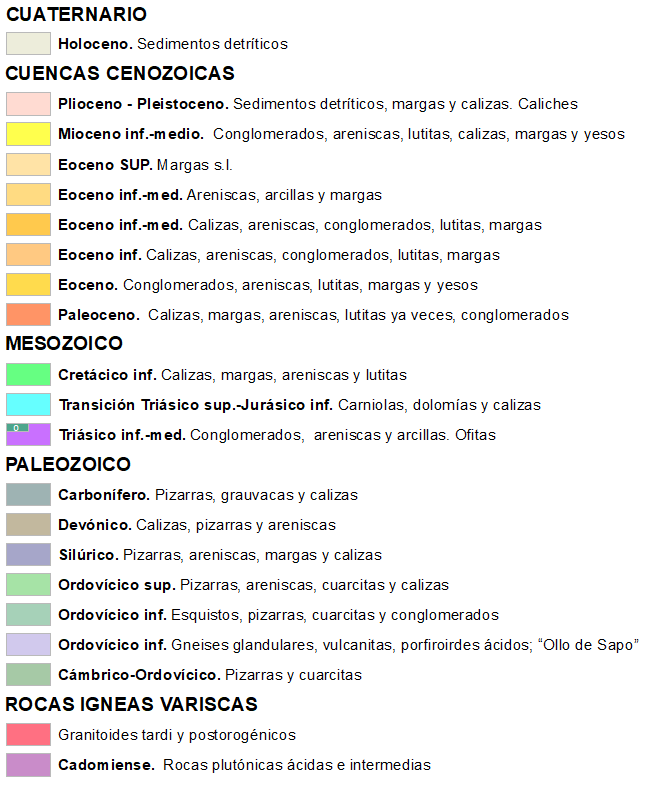
The Pyrenean mountain range includes all the mountainous alignments that rise on the northern edge of the Iberian plate from Cape Creus (Mediterranean Sea) to Galicia, i.e. the rocks and Pyrenean structures continue laterally to the west by the reliefs of the Cantabrian cornice and by the continental margin submerged under the Cantabrian Sea: there is a "Pyrenees" under water to the northern coasts of Galicia The two most important alignments are the Cantabrian mountain range and the Pyrenees. The separation between the two is established in the Pamplona fault, a NNE-SSO fracture 120 km long with an important jump in direction and sinestral sense. The northern limit is the frontal dipping over the Aquitaine basin, in the case of the Pyrenees, and the Bay of Biscay, in the case of the Cantabrian mountain range. The southern limit is also frontal dipping on the tertiary basins of the Ebro, in the Pyrenees, and the Duero, in the Cantabrian.
The Pyrenean mountain range extends eastwards in the French region of Languedoc and Provence, until it connects with the Alpine belt, and westwards in the Atlantic until it reaches the so-called "King´s Trough" (an underwater channel 400 km long and heading NW-SE) in the vicinity of the Atlantic ridge.
The Pyrenees extend from the Bay of Biscay to the Gulf of Lion. The western boundary is the alignment separating the Mesozoic Basque-Cantabrian basin from the Tertiary Basin of Jaca-Pamplona. Today, the Pyrenees constitute a fossil plate boundary. During the Mesozoic, the Pyrenean area had a cortical extension and thinning, vulcanism, development of sedimentary basins and separation between Iberia and Europe. Subsequently, 85 Ma ago, from the final Cretaceous and for more than 60 Ma to the lower Miocene, the oblique convergence, collision and subduction of lberia under the Eurasian plate caused deformation of the stratified sedimentary basins, involving the underlying varicose substrate, which rose to the present 3,300 metres.
Pyrenees is a mountain range of double vergence in which two stripes are distinguished separated by the norpyrenean fault where the subduction of Iberia takes place under the European lithosphere and where there is a Mould jump of 10-15 km with a thickening of the crust under the axial zone. The overlap between the two plates is moderate and much of the shortening in depth observed in the seismic profiles is resolved by numerous intracortical dips affecting the lower crust of both plates. The northern strip presents dipping and folds of varicose and mesozoic materials verging to the north. In the southern strip we can distinguish the axial zone, an asymmetrical anti-shape verging to the south and with immersion to the west composed of igneous and metamorphic varist rocks that also emerge in the western Basque massifs. These varicose materials have more affinity with those that emerge in the Catalan coastal chains, Sardinia or part of the Alps than with those that appear in the Iberian Massif.
The Pyrenees have neither magmatism nor synorogenic metamorphism of importance. Only in the norpyrenean fault does an alpine thermal metamorphism develop. To the west, this fault is poorly defined.
In the southern or southern Pyrenean zone there are postvariscos materials with vergentes structures to the south, that form the cover of the axial zone. In the Permian, the calcoalkaline magmas favored by tardivarisca tectonics are located.
The Pyrenees have a structural geology of surface with folds and dipping typical of high cortical levels. General tectonics began with a transpressive episode and a final compressive phase that affected the Palaeozoic materials of the basement and the Mesozoic and tertiary successions. The lower crust and Iberian Moho dip northwards below the European continental crust. Cortical thickening is caused by dipping that even affects the mantle, and reaches 55-60 km below the axial zone. The structure of the upper cortex is defined as an orogenic prism of double vergence.
The structure of the southern Pyrenean front over the Ebro basin extends for more than 200 km, affecting from the Middle Triassic to the Miocene, with thicknesses of more than 6,000 m. They give rise to the so-called marginal sierras and external sierras.
It is thought that the Pyrenean seismicity could be due to the reactivation of some old faults produced during the orogenic stage.
| © Instituto Geográfico Nacional - C/ General Ibáñez de Ibero, 3. 28003 Madrid - España.
ign@fomento.es |


