
The current state of the northwestern portion of the Iberian Peninsula is the result of a complex tectonic evolution in which three different phases are distinguished.
The first tectonic phase is compressive and linked to the Hercynian orogeny, origin of the Iberian Massif. This orogeny shows different phases and was active along most part of the mid and late Paleozoic. Its origin is the collision between the Euroamerican and Gondwana landmasses that ended up with the formation of the Pangea supercontinent.
The second tectonic phase is distensive and active along the Mesozoic. During this phase the Atlantic Ocean opened and therefore Pangea supercontinent got fractured. In the case of the northern margin of the Iberian Peninsula, its evolution was controlled by the counterclockwise movement to the SE of the Iberian plate independently from the rest of Europe. This movement resulted in the separation of the Eurasian and Iberian plates and the subsequent opening the Gulf of Bizkaia.
The third tectonic phase is compressive and active along the Cenozoic. It is related to the Alpine orogeny caused by the collision between the Eurasian and the African plate. This event resulted in an opposite geodynamic regime compared to the previous phase, and as a consequence of the convergence between Eurasia and Iberia, the partial closure of the Gulf of Bizkaia and the uplift of the Cantabrian Mountain Range occurred.
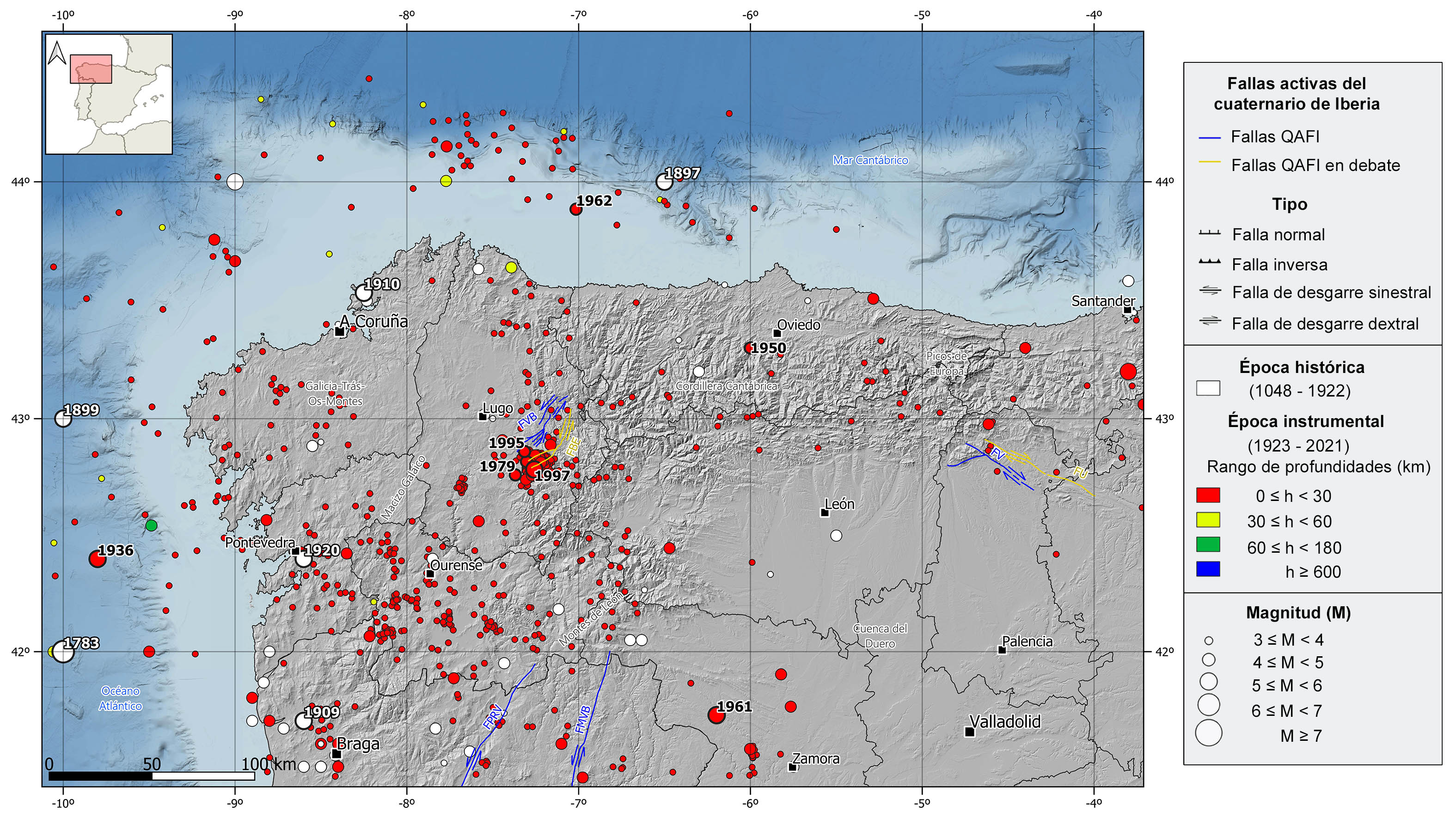
Because of this complex tectonic evolution, there are a large number of inverse or strike-slip faults of paleozoic age that were reactivated as normal faults during the extensive phase and recovered back as inverse and strike-slip faults during the Alpine orogeny. Some of these faults show evidence of recent activity (Pliocene and Quaternary) and associated seismicity. Three remarkable sinistral transform fault systems exist in the region, the NE-SW Vilachá-Baralla-Becerreá in Lugo, and two NNE-SSW systems, Penacova-Régua-Verín and Manteigas-Vilariça-Bragança, in the NE of Portugal. It is also worth mentioning the NW-SE Ventaniella and Ubierna dextral transform system to the SE of the Cantabrian Mountain Range. Despite the Ventaniella fault is 200 km long inland and extends 150 km more offshore, it is only active in its southern segment.
| © Instituto Geográfico Nacional - C/ General Ibáñez de Ibero, 3. 28003 Madrid - España.
sismologia@transportes.gob.es |


