
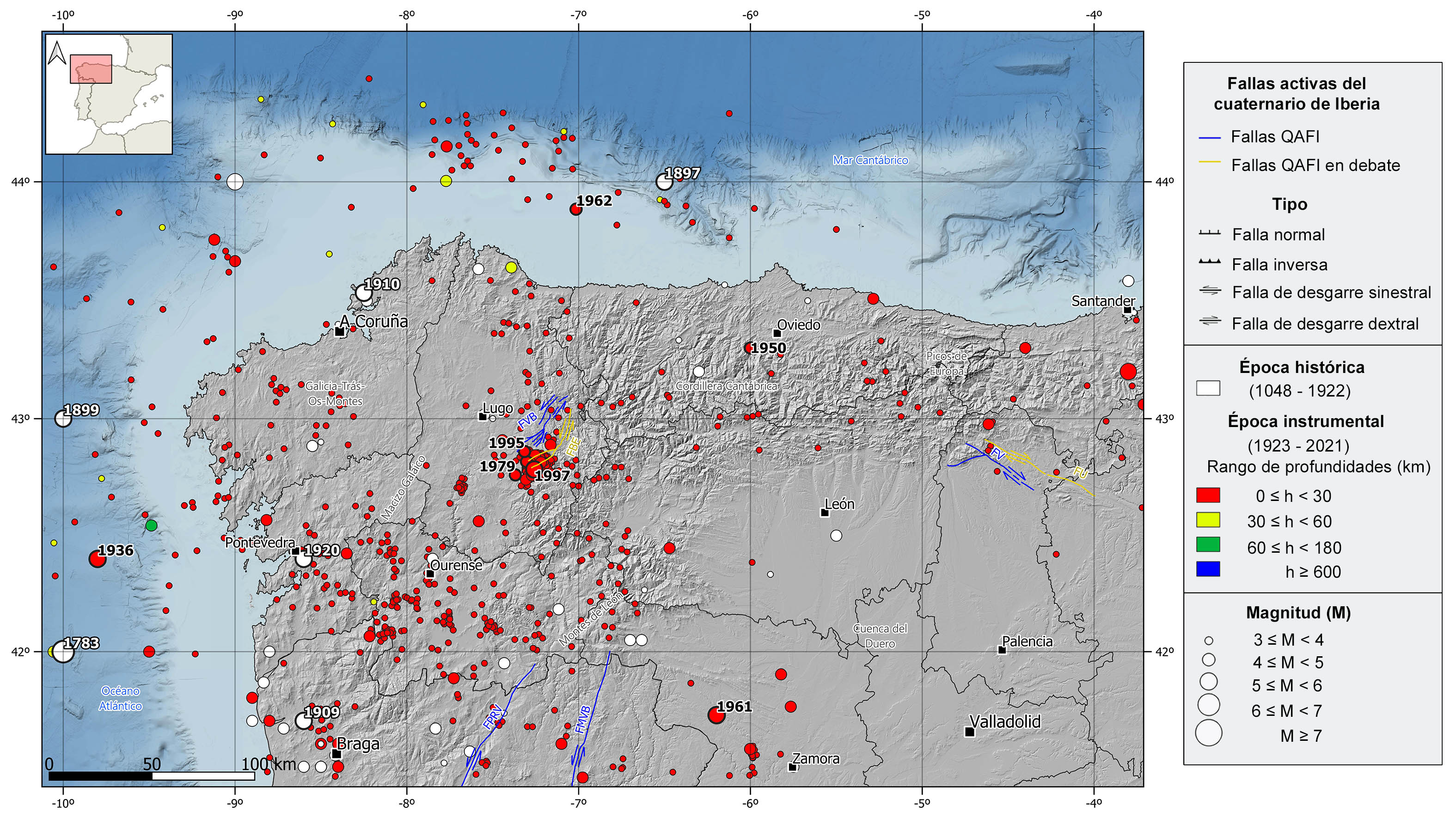
The NW of the Iberian Peninsula is currently considered a seismically stable zone of low to moderate-magnitude seismicity, within the general seismotectonic context of Iberia. Nevertheless, it presents some remarkable seismic series and earthquakes of moderate magnitude. Seismicity in this area is shallow (depths <30 km) and, although scarce, focal mechanisms of normal and strike-slip type predominate. The south and east of Galicia is the area with the highest number of earthquakes, while in the rest of the region seismicity is scattered, with some earthquakes with marine epicenter, both in the Atlantic and Cantabrian coasts.
In the historical catalog we can highlight several earthquakes of estimated magnitudes greater than 5. With epicenter in the sea, the 1783 and 1899 events in the Atlantic Ocean, and the 1897 in the Cantabrian Sea stand out. These earthquakes were felt with maximum intensities of VI-VII, VI, and V-VI, respectively. On land, there are worth mentioning the 1909 Viana do Castelo (Portugal), 1910 El Ferrol, and 1920 Pontevedra earthquakes, all felt with intensity VII. In addition to these, in the first two decades of the 20th century, several earthquakes of intensity VI and magnitude slightly lower than 5 have been catalogued, mainly in the northwest of Portugal and southwest of the province of Pontevedra.
In the instrumental period, three earthquakes of magnitude around 5, felt with maximum intensities of VI, can be highlighted: the 1950 (M4.7) Teverga (southwest of Oviedo) event and two earthquakes occurred in 1961 west of Zamora of magnitude 5.3. But most of the seismicity is concentrated around the Sarria-Becerreá-Triascastela (Lugo) area, where three significant seismic series occurred in 1979, 1995, and 1997, with maximum magnitude earthquakes of 4.6, 4.7 and 5.2, respectively.
With epicenter in the sea, there are also two remarkable earthquakes of moderate magnitude: the 1936 (M5.1) earthquake in the Atlantic Ocean, offshore the coast of Pontevedra, and the 1962 (M4.4) in the Cantabrian Sea, offshore the coast of Lugo. These earthquakes were felt with maximum intensities V and VI, respectively. In the last two decades, there have been some scattered earthquakes in the provinces of Zamora and León and in the Cantabrian and Atlantic coasts, with magnitude slightly above 4 felt with intensities between IV and V.
| © Instituto Geográfico Nacional - C/ General Ibáñez de Ibero, 3. 28003 Madrid - España.
sismologia@transportes.gob.es |


