
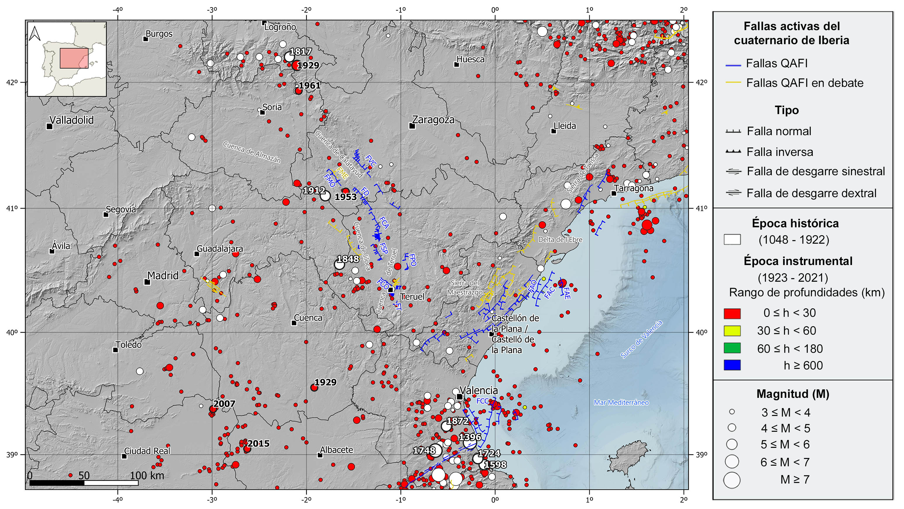
This region is characterized by a low to moderate seismicity, with the occurrence of some destructive historical earthquakes. The epicenters are mostly concentrated in the southeastern and northwestern sectors of the mountain range, with some scattered earthquakes in the central zone. It is a shallow crustal seismicity (<25 km depth), with hypocenters mainly located between 5 and 15 km depth. The available focal mechanisms in the area, although scarce, are consistent with the current extensional tectonic regime, with predominance of normal fault type sources.
In the historical catalog, in the northern and central part of the Iberian Chain, it is worth mentioning the 1817 Prejano (La Rioja) earthquake with maximum intensity VII-VIII, 1848 Orihuela del Tremendal (Teruel), and 1912 Cimballa (Zaragoza) earthquakes, both felt with maximum intensity VI-VII and estimated magnitude above 5. In this area there have also been several events with an estimated magnitude slightly lower than 5 and a maximum intensity of VI. In the southeast sector, in the boundary with the northeasternmost Betics, some significant historical destructive earthquakes reaching intensity IX and estimated magnitude larger than 6 have been catalogued in the province of Valencia. This is the case of 1396 Tavernes de Valldigna earthquake, which caused the collapse of hundreds of houses in Tavernes, and the 1748 Estubeny earthquake, which destroyed de towns of Montesa, Sellent and Estubeny. Other noteworthy events of estimated magnitude above 5 are the 1598 Oliva, with intensity VII-VIII, and the 1724 Gandía and 1872 Carlet earthquakes, both with intensity around VII.
In the instrumental period, in the northern sector of the Iberian Chain, we can highlight the 1929 (M5.2) Turruncún (La Rioja) earthquake, with intensity VI-VII, as well as several events of magnitude slightly larger than 4.5 and felt with maximum intensities between VI and VII. Such as the 1929 Motilla Palancar (Cuenca), 1953 Used (Zaragoza), or the 1961 Aguilar Rio Alhama (Logroño) earthquakes. However, the southeastern region of the mountain range has not suffered any significant earthquake over the last century. Nevertheless, it is noteworthy some seismicity at sea, in the Gulf of Valencia, where the 2003 seismic series stands out, with the largest earthquake of magnitude 4.2 felt with intensity V. More recently, to the southwest of the Iberian Chain, two earthquakes are worth mentioning: the 2007 Pedro Muñoz (Ciudad Real) and the 2015 Ossa de Montiel (Albacete) events, both of magnitude 4.7 and felt with a maximum intensity of V.
| © Instituto Geográfico Nacional - C/ General Ibáñez de Ibero, 3. 28003 Madrid - España.
sismologia@transportes.gob.es |


