
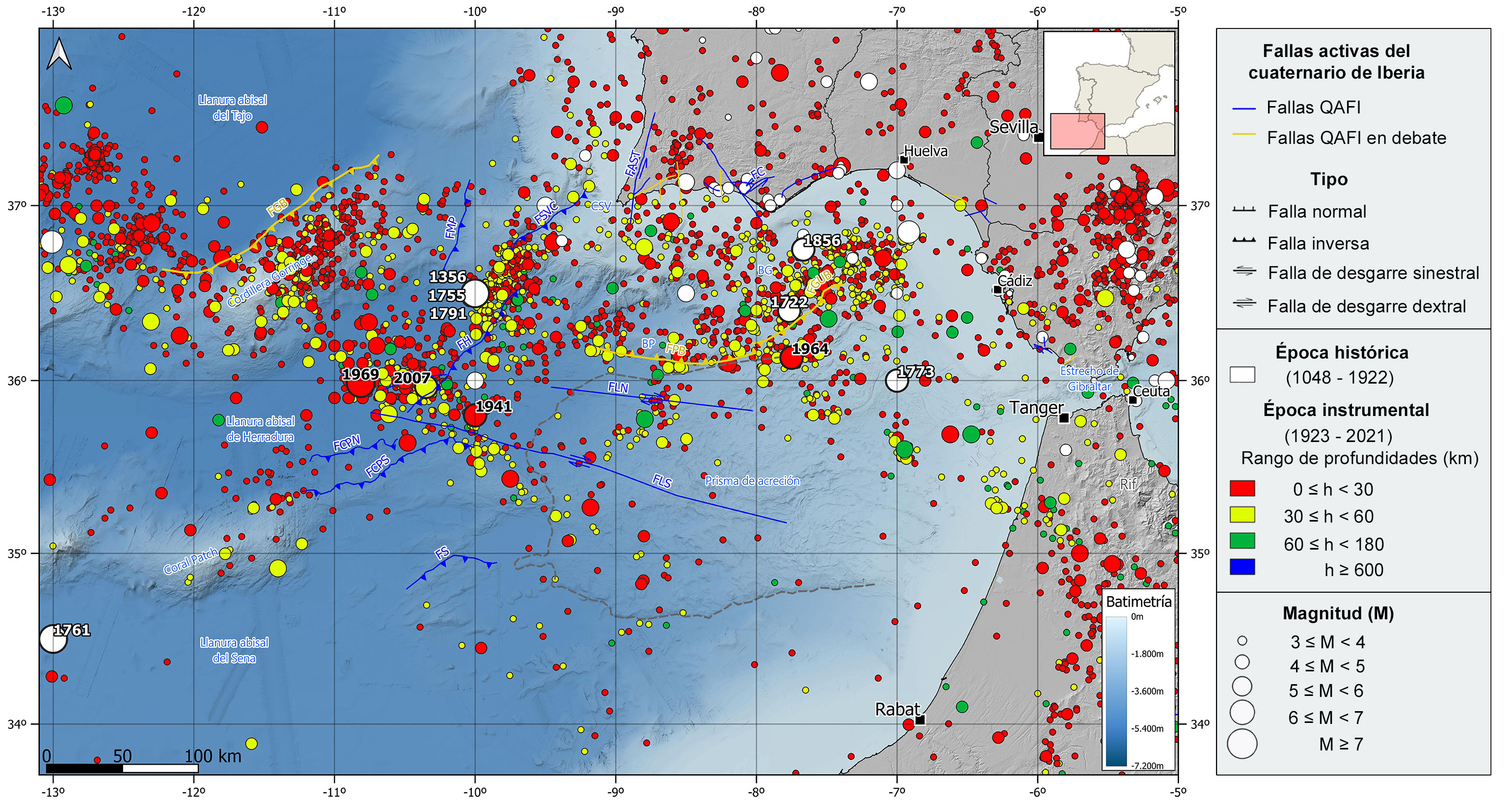
This area is characterized by a moderate-magnitude seismicity, although some of the largest known earthquakes in the surroundings of the Iberian Peninsula have also occurred, constituting one of the regions with highest tsunami hazard in the Atlantic Ocean. In fact, in this area, three earthquakes that have generated tsunamis and affected the Spanish coasts have been catalogued. In addition, other events within this region have caused tsunamis that have affected at least the Portuguese coasts.
The seismic activity in this region reflects the complex convergence between the African and Eurasian plates in the area, without any clear epicentral alignment. In fact, most earthquakes are distributed in clusters, mainly located in the northern half of the Gulf of Cadiz, extending to the western part of the Gorringe Bank. This seismicity seems to be generated in the lithospheric mantle rather than in the crust, with hypocenters located mainly between 30-40 km depth and, in some cases reaching 50-60 km depth, but without clearly drawing a subduction zone. This could be explained by a fragile behavior of the old and cold oceanic lithosphere up to the upper mantle. Although there is still poor knowledge of the relationship between this seismicity and the geologically mapped active faults in the area, most of the available focal mechanism are reverse and strike-slip types with a maximum horizontal compression in the NW-SE direction.
Historically, the largest and most important earthquake ever recorded is the 1755 earthquake, also known as the Lisbon earthquake. Located SW Cape St. Vincent, it has an estimated magnitude of 8.5 and was felt in the south of Portugal with a maximum intensity of X, all western Europe, and North Africa. This earthquake generated a tsunami with waves reaching 10-15 meters height in the Gulf of Cadiz. In the westernmost end of this region, it is also noteworthy the 1761 earthquake, located to the SW of the Coral Patch Seamount, with a similar estimated magnitude of 8.5, reached a maximum intensity of IX. This earthquake was also felt in different areas of Europe and caused a tsunami that reached the coasts of Portugal, Spain, Great Britain and even Barbados, although with much less severity than that of 1755. Other important historical earthquakes are those occurred in 1356 and 1791, located to the southwest of Cape St. Vincent, in the vicinity of the 1755 earthquake. The former was felt with a maximum intensity of VIII and has an estimated magnitude around 7.6, the latter with a maximum intensity of VI and estimated magnitude around 6.2. In the Gulf of Cadiz, it is worth mentioning the 1722 earthquake, with an estimated magnitude of 6.0, which devastated several localities in the south of Portugal, where reached intensity VIII, and caused a local tsunami that flooded shallow areas of Tavira. Further south, also remarkable is the 1773 earthquake, with an estimated magnitude of 6.5, and felt with a maximum intensity of VII. Offshore Portugal there was also an earthquake in 1856 with an estimated magnitude of 6.2 and felt with a maximum intensity of VII-VIII.
In the instrumental period, the most important earthquake in this area was the 1969 earthquake (M7.8), located southwest of Cape St. Vincent, in the Horseshoe abyssal plain. This earthquake was felt with maximum intensities of VIII-IX and VIII in several locations in southern Portugal and produced a small tsunami on the coasts of Morocco, Portugal and Spain. Also noteworthy are the 1941 earthquake (M6.7) and the 1964 earthquake (M6.6) in the Gulf of Cadiz, which was felt with a maximum intensity of VII. More recently, two earthquakes occurred in 2007 (M6.1) and 2009 (M5.7), located in the vicinity of the 1969 and 1755 earthquakes, respectively, both felt with a maximum intensity of IV.
| © Instituto Geográfico Nacional - C/ General Ibáñez de Ibero, 3. 28003 Madrid - España.
sismologia@transportes.gob.es |


