
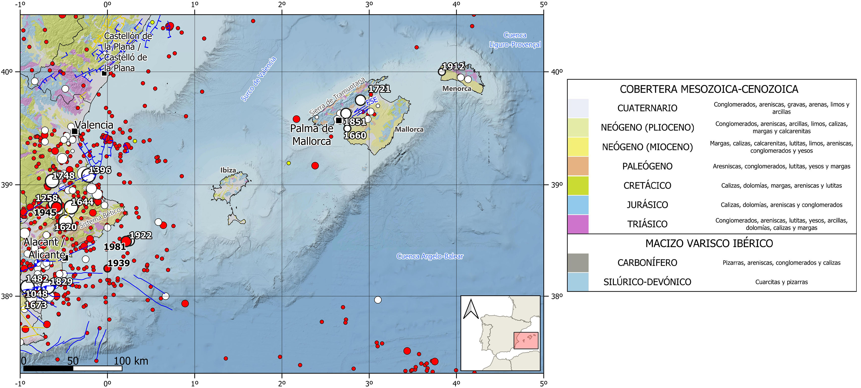
The seismicity in the Betic-Balearic domain is mainly clustered at its southeastern edge, in the Eastern Betic Cordillera which is characterized by a shallow crustal seismicity (<30 km depth) of moderate magnitude, with the occurrence of some large destructive earthquakes. This seismicity is related to the shear active fault systems that cross the crust, with predominance of strike-slip focal mechanisms. On the contrary, seismicity in the Balearic block is very scarce and dispersed and of low magnitude (mostly M <4).
Nevertheless, the Balearic archipelago presents some tsunami hazard, its coasts have been affected by tsunamis generated by earthquakes offshore the Algerian north coast. In fact, in the IGN catalog there is evidence of two tsunamis that have affected the Balearic Islands. One historical, due to an earthquake in 1856 of estimated magnitude 6.6 that caused the sea level to rise and damage to the port of Mahón. And the most recent, in 2003, generated by another earthquake off the coast of Algeria of Mw 6.8, which took about 45-50 min to reach the islands of Ibiza and Palma de Mallorca and caused material damage to boats in several ports of the islands, being the maximum wave height recorded of 2 m.
In the historical period, the highest estimated magnitudes and maximum historical intensities recorded in Balearic sector have been M5.4 and intensity VII for two earthquakes located in the Island of Mallorca, one occurred in 1721 in Selva and other in 1851 in La Cabaneta. It is also worth mentioning several earthquakes felt with a maximum intensity of VI, one in 1660 in Ibiza and another in 1912 in Ciudadela (Menorca) with an estimated magnitude of 4.9.
Recent seismicity in the Balearic block is scarce, of low magnitude (M<3) and scattered, mainly located in the Mediterranean Sea between Mallorca and Ibiza Islands at depths between 1-30 km. However, sporadically, some earthquakes of magnitudes between 3 and 4 also occur, being 4.3 the maximum magnitude recorded in the instrumental period. The maximum intensities observed generally range between II and III, being a value of IV the maximum observed intensity to date.
| © Instituto Geográfico Nacional - C/ General Ibáñez de Ibero, 3. 28003 Madrid - España.
sismologia@transportes.gob.es |


