
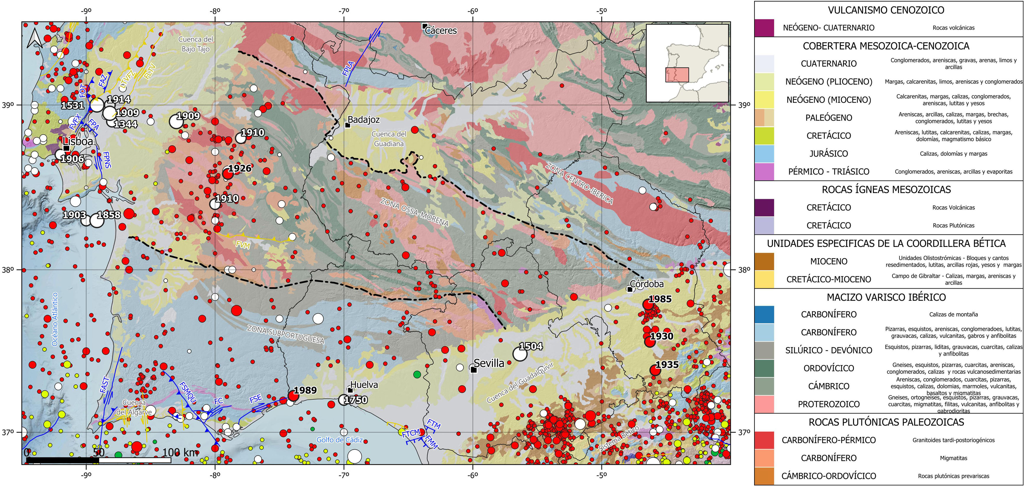
This region encompasses the southwestern margin of the Iberian Peninsula. It extends in the E-W direction along 450 km, from the west of the Jaen province to the Atlantic Ocean coast in Portugal. The southern boundary is the Betic Cordillera to the east, and the Atlantic Ocean along the southern coast of Portugal to the west. The northern limit is more arbitrary, it is an imaginary E-W line going through Caceres city and defined by the end of the Iberian Massif rock outcrops characterizing this region. Besides the Iberian Massif units, this region includes 3 relevant sedimentary basins, the Bajo Tajo River basin to the west, the Guadiana River basin to the north, and the Guadalquivir River basin to the southeast.
Geologically speaking, this region mainly corresponds to the central portion of the Iberian Massif, which is the group of precambrian and paleozoic rocks that were mostly deformed and metamorphized during the Hercynian or Variscan orogeny. This orogeny was the origin of a mountain belt, currently quite eroded and partially buried, that in Europe extends along over 3,000 km from the Guadalquivir River to Central Europe and the Balkans. The Iberian Massif is the southern portion of this mountain belt, and it is the best-known record of the Hercynian orogeny effects.
The Iberian Massif dominates the rock outcrops in the western part of the Iberian Peninsula, and therefore, in this region. The Iberian Massif is divided into five different zones. From east to west and from north to south these zones are, the Cantabrian zone, the Western-Asturian-Leonese zone, the Center-Iberian zone, where it is included the Galicia-Trás-Os-Montes subregion, the Ossa-Morena zone and the Subportuguese zone. The Ossa-Morena and Subportuguese zones are the main ones in this region, although the Center-Iberian is also present in NE portion.
One of the more complex and less known zones of the Iberian Massif is the Ossa-Morena Zone. It has a trapezoidal geometry and it is characterized by the presence of large-scale folds and thrust faults. It limits to the north with the Center-Iberian zone along the Badajoz-Córdoba Shear Zone, and to the south with the Subportuguese Zone along the South Iberian Shear Zone. These shear zones are Variscan time sutures, it means, collision and joining areas between two continents previously separated by an ocean. The Subportuguese Zone is also present in this region and shows a complex and strongly folded structure as well because of its collision and joining with the other Iberian Massif units.
Moreover, the Iberian Massif is buried and acts as the basement in the Guadalquivir River basin to the SE, in the Bajo Tajo River basin in Portugal to the NW, and in the Guadiana River basin to the north. The sediment infill in the Guadiana and Bajo Tajo River basins is mainly clastic and continental. The geological story of the Guadalquivir River basin is more complex due to its location in between the Iberian Massif and the Betic Cordillera. Initially, it was a communicating channel between the Mediterranean Sea and the Atlantic Ocean, so, the sediments deposited on it were coming from both coasts, the one formed by the Iberian Massif to the NW, and the one formed by the Betic System to the SE. Therefore, the sediment infill of this basin shows high variability, being remarkable the Olistotromic Unit deposited during the Miocene as a wedge-shape complex composed by a chaotic mass of big blocks mixed with recently formed sediments, and also, the turbiditic sands deposited at the bottom of the basin which are the main sediment infill of the basin.
This region also includes the Algarve sedimentary basin. It is located along the southern coast of Portugal and its sediment infill shows the evolution from a continental to a marine environment along the Triassic and the Jurasic periods (Mesozoic).
| © Instituto Geográfico Nacional - C/ General Ibáñez de Ibero, 3. 28003 Madrid - España.
sismologia@transportes.gob.es |


