
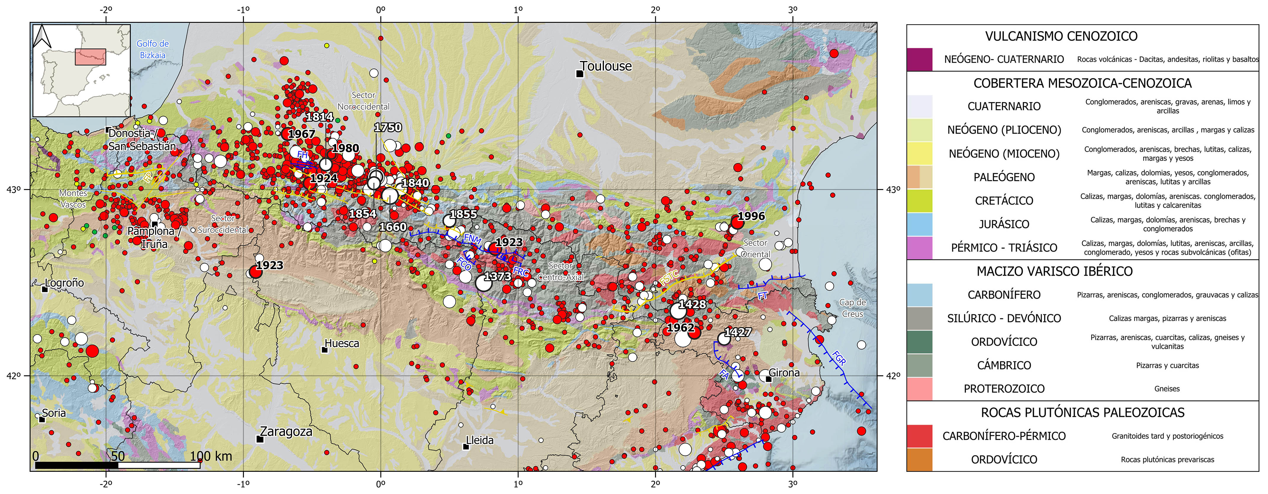
The Pyrenees is characterized by a moderate-magnitude seismicity, mainly of shallow depth ( <30 km)), although in this region the crustal thickness can reach 50 km depth in some areas. The predominant focal mechanisms are of normal fault type, with the stress axes perpendicular to the mountain range, in concordance with the actual tectonic regime and the GNSS observed displacement data.
The eastern sector of the Pyrenees presents a moderate and scattered seismic activity, but it has also been hit by some large destructive historical earthquakes. During the historical period, it is noteworthy the 1427-1428 seismic series, with the occurrence of several earthquakes of estimated magnitude above 6 in the province of Girona: the 1427 event in Olot, with maximum intensity of VIII-IX, and the 1428 event in Queralbs. The latter had a maximum intensity of IX-X and caused the destruction of the city and about 800 casualties. During the instrumental period, it can be noticed the 1962 (M5.2) and the 1996 (M5.1) earthquakes in the province of Girona and the eastern sector of the French Pyrenees, respectively.
In the central sector of the Pyrenees, in the historical period, it is worth mentioning the 1373 in Ribagorça (Lleida) earthquake with intensity VIII-IX and estimated magnitude of 6.2. During the instrumental period, stands out the 1923 Vielha (Lleida) earthquake with intensity VIII and estimated magnitude around 5.8. Several studies suggest the Maladeta North fault as the possible source of both events.
The northwestern sector is the most seismically active region of the Pyrenees, highlighting two historical earthquakes with estimated magnitude around 6: the 1660 Bagneres-de-Bigorre and the 1750 Lourdes earthquakes, with maximum intensities of VIII-IX y VIII, respectively. Several other significant events have occurred in this region, the largest of estimated magnitude 5.8 and intensities VII and VII-VIII in 1750, 1840, 1854, and 1855. Further west, there was also an important earthquake in 1814 in Arduy of intensity VII-VIII. During the instrumental period, there are noteworthy the 1924 Laruns, and the 1967 Arette earthquakes, both of magnitude 5.4 and intensity VIII, and the 1980 Arduy event of magnitude 5 and felt with a maximum intensity VII. To the south of the Pyrenees, it is also worth mentioning an earthquake in 1923 in the Canal of Berdún (Huesca-Zaragoza) of intensity VII and magnitude 5.7.
Finally, in the southwestern region, in the boundary with the Basque Mountains, the most relevant seismicity, of lower magnitude and intensity than in the rest of the Pyrenees, clusters around the city of Pamplona, where several earthquakes of magnitude between 4.5 and 5 and maximum intensities V and VI, have been recorded in 1903, 1982, 2004, and 2020.
| © Instituto Geográfico Nacional - C/ General Ibáñez de Ibero, 3. 28003 Madrid - España.
sismologia@transportes.gob.es |


