
The Pyrenees raised during the Alpine orogeny, a large-scale tectonic process active since the late Mesozoic and during most of the Cenozoic. At small scale, this orogeny was linked to three tectonic events creating a compressive stress field responsible of the Iberian Peninsula evolution. In the northern area, the subduction of the oceanic crust in the Gulf of Bizkaia under the Iberian plate and the collision of the Iberian and Euroasian plate were responsible of the Cantabrain Mountain Range and the Pyrenees uplift respectively. In the southeast area of the Peninsula, the collision between the Alboran and Iberian plate created the Betic System.
In the current Pyrenees region, the pre-orogeny stage was dominated by an extensional regime that created mesozoic sedimentary basins infilled with jurassic and cretaceous thick marine sediment series.
During the orogenic stage, the Pyrenees were uplifted and folded, involving both the paleozoic basement and the mesozoic sedimentary basins. Moreover, it created the source rock area of the cenozoic sediments that were deposited in the foreland basins to the north and south of the mountain range (Aquitaine and Ebro basins).
In this orogenic stage, the oblique convergence, collision and subduction of the Iberian microplate under the Eurasian plate, resulted in a transpressive and compressive stress field that lasted till the Miocene (late Cenozoic). The mountain relief started appearing at the east and was progressively moving westwards as the subduction process advanced and the oceanic trough separating Iberia and Europe mainland in the western area got closed.
Therefore, the Pyrenees is a fossil plate boundary between the Iberian and Eurasian plates and its surface expression is the North Pyrenean fault, a large tectonic structure crossing the Pyrenees from east to west.
The current post-orogenic stage started with the relax and ending up of the Alpine orogeny and does not show a dominant stress field. Nevertheless, geodesy data shows a very slow extension perpendicular to the mountain range, where the main active faults are normal faults and result from the reactivation and inversion of reverse fault of the orogenic stage.
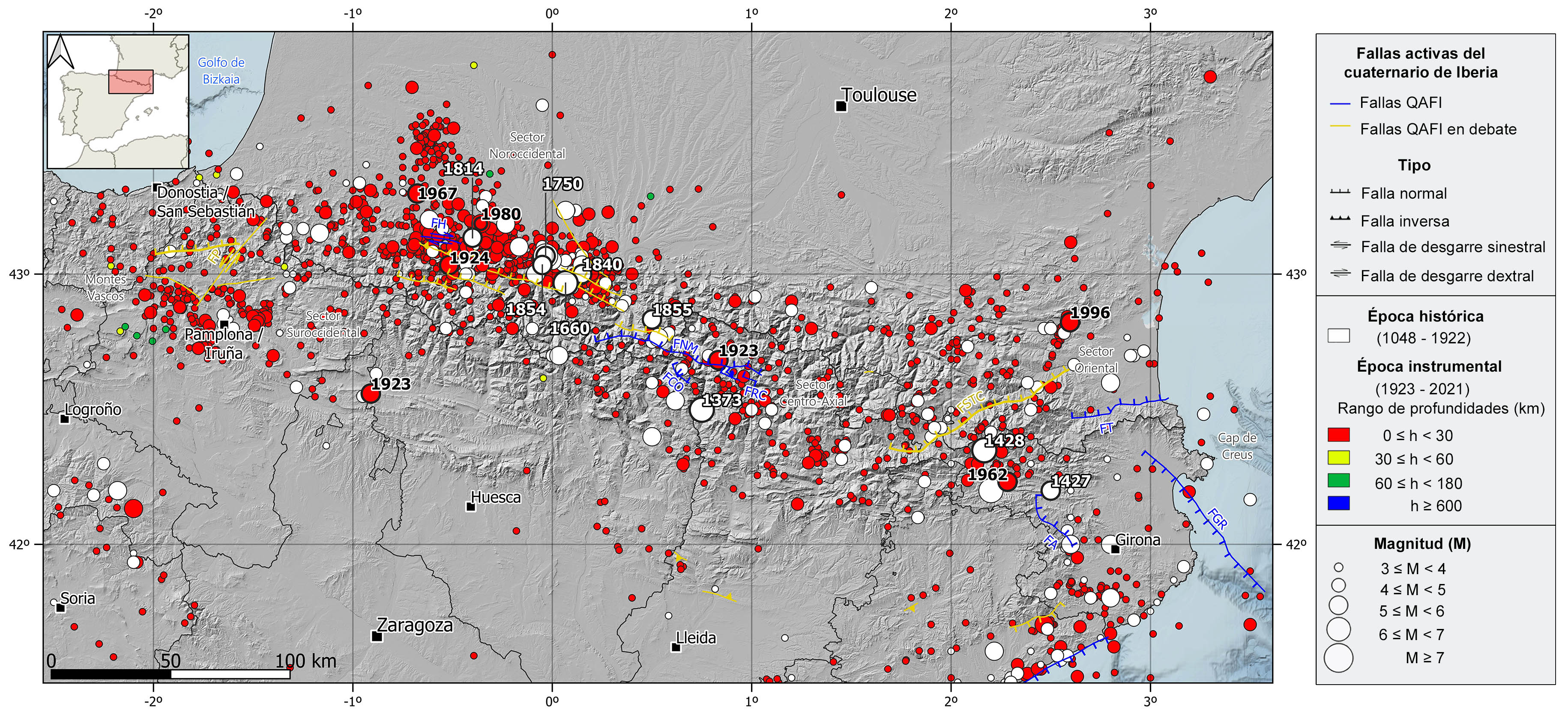
Regionally, the Pyrenees Mountain Range can be split in four different sectors with some remarkable active fault series. In the eastern sector, the Sud de la Tet-Cerdanya fault system which extends NE-SW along 120 km, the ENE-WSW Tech faults and the NW-SE Amer and Gulf of Roses faults. In the Center-Axial sector, numerous E-W to WNW-ESE faults strongly dipping to the north and with associated seismicity, the Coronas, Rius-Cabanes, and Maladeta North faults are the best examples. In the northwestern sector, the WNW-ESE dextral strike-slip Herrere fault and many normal type structures with similar orientation whose quaternary tectonic activity is under debate. In the southwestern sector, there are several faults whose recent activity is currently under debate, the NNE-SSW sinistral strike-slip with normal movement component Pamplona fault is the main one.
The current deformation rate in the Pyrenees is very low, below 1 mm/yr, but nevertheless, the Pyrenees shows a continuous seismic activity and is the second most active seismic region in the Iberian Peninsula.
| © Instituto Geográfico Nacional - C/ General Ibáñez de Ibero, 3. 28003 Madrid - España.
sismologia@transportes.gob.es |


