
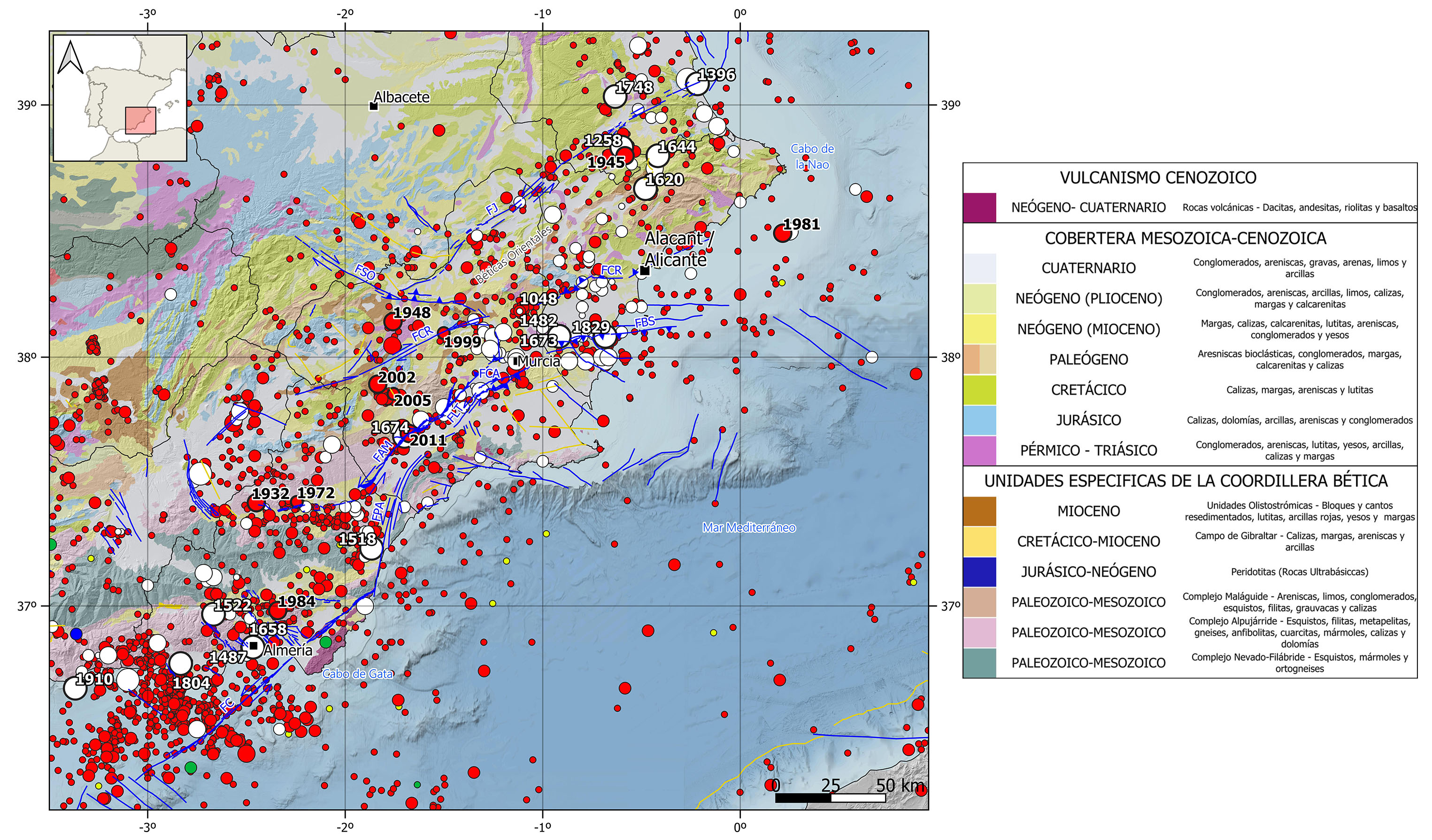
The Eastern Betic Cordillera is characterized by a shallow crustal seismicity (<30 km depth) of moderate magnitude, with the occurrence of some large destructive earthquakes. This seismicity is related with de shear active fault systems that cross the crust, with predominance of strike-slip focal mechanisms.
In the historical catalog, the largest event occurred in this region is the 1829 Torrevieja (Alicante) earthquake, felt with maximum intensity IX-X and with an estimated magnitude of 6.6. It is one of the largest and most virulent events recorded in the Iberian Peninsula and caused around 400 fatalities and the destruction of Torrevieja and Guardamar. Other remarkable historical earthquakes can be cited, felt with intensities VIII-IX and with estimated magnitudes around 6.2-6.5. In the southern end of this region, it is noteworthy the 1518 Vera earthquake, which caused over 165 deaths and around 200 houses destroyed, the 1522 Alhama de Almería earthquake, with 1000 fatalities and big destruction in Almería and Ugijar, and the 1804 Dalías earthquake, which produced around 400 deaths and the destruction of Dalías, Berja and Roquetas. In the northernmost Betics, in the province of Valencia, the 1396 Tavernes de Valldigna earthquake, which caused the destruction of hundreds of buildings in Tavernes, and the 1748 Estubeny earthquake, which destroyed the populations of Estubeny, Montesa and Sellent and caused 38 fatalities can be highlighted. Other significant historical earthquakes, with maximum intensities between VIII and VIII-IX and estimated magnitude around 6, are, from north to south: the 1258 Ontinyent (Valencia); the 1620 and 1644 Alcoy and Muro de Alcoy (Alicante), respectively; the 1048, 1482, and 1673 Orihuela (Alicante); the 1674 Lorca (Murcia); the 1487 and 1658 Almería; and the 1910 Adra (Almería) earthquakes.
In the instrumental catalog, there have been several remarkable earthquakes with magnitudes around 5 and maximum intensities between V and VII. In the southern sector, three earthquakes in the province of Almería are noteworthy: the 1932 Lucar, 1972 Partaloa, and 1984 Tabernas earthquakes. In the central sector, several earthquakes in the province of Murcia stand out: the 1948 Cehegín, 1999 Mula, 2002 Bullas, and 2005 La Paca-Aledo earthquakes, as well as the most recent 2011 Lorca Mw 5.1 earthquake. The latter was felt with a maximum intensity of VII, causing 9 fatalities and significant damage to buildings. It is the largest earthquake recorded in this area in this century. In the northeastern end of the Cordillera, the recent seismicity is scarce; however, it is worth mentioning the 1945 Onteniente (Valencia) earthquake, with magnitude 5.4 and an intensity of VII. With epicenter in the Mediterranean Sea, we can highlight an earthquake in 1981 with magnitude 5.1 and a maximum intensity of V, located offshore the coast of Alicante.
| © Instituto Geográfico Nacional - C/ General Ibáñez de Ibero, 3. 28003 Madrid - España.
sismologia@transportes.gob.es |


