
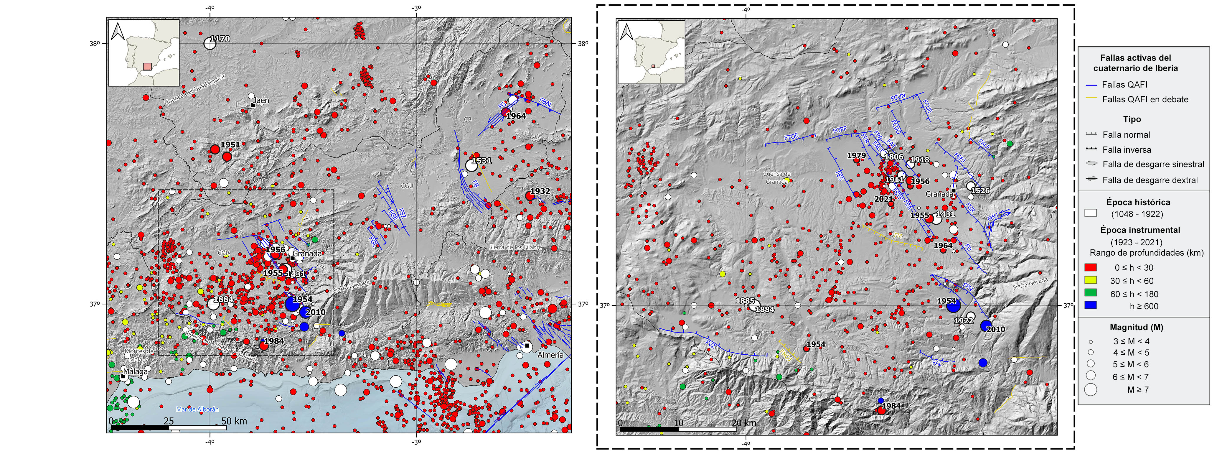
Seismicity in the Central Betic Cordillera is mainly concentrated in the inland zone, in the neogene basins, while the mountain range remains inactive. In fact, the Granada Basin is the most seismically active and one of the areas with the highest seismicity rate of the Iberian Peninsula. The seismicity is mainly located within the crust, at shallow depths (<30 km) and low to moderate-magnitude earthquakes predominate, although with the occurrence of several of the largest and most destructive earthquakes registered in the Peninsula. This shallow seismicity is largely controlled by the normal active fault systems that cross the intramountain basins, with the predominance of normal type focal mechanisms, in concordance with the ENE-WSW extensive tectonic regime of the area.
A significant set of earthquakes at intermediate depths (40-150 km) also occur in the southwestern most end of this region, in the province of Málaga. Occasionally, there are also some very deep earthquakes (>600 km depth) with epicenter south of the city of Granada, probably related with the tectonic evolution and dynamic processes of the mantle in the Gibraltar Arc. The existence of this seismicity has given rise to different theories about its origin on which there is still no agreement. Some of the proposed models consider convection or delamination processes or subduction of different types, generally accompanied with roll-back processes.
Historically, several events with estimated magnitudes between 6.2-6.5 and maximum intensities of VIII-IX can be highlighted as examples of the most important shallow earthquakes in this area. From east to west, the 1531 earthquake in the Baza basin (Granada), which caused 400 fatalities and the destruction of more than 60% of the houses in Baza. Also, two earthquakes in the Granada basin: one in 1431, south of the city of Granada, which caused great damage to the Alhambra, and another one in 1884 in Arenas del Rey. The latter was felt with intensity IX-X and is one of the largest and most destructive historical earthquakes recorded in the Iberian Peninsula. It caused tens of thousands of damages, buildings destroyed and around 840 deaths. Further north, on the boundary between the Betic Cordillera and the Iberian Massif, in the easternmost part of the Guadalquivir basin, the 1170 earthquake in Andújar (Jaén) is also worth mentioning.
In the instrumental catalog, the largest recorded earthquakes have been deep earthquakes, with epicenter south of the Granada basin at depths of more than 600 km. These include the 1954 Dúrcal earthquake (M7.8) and the 2010 Nigüelas earthquake (M6.3). At shallow depth, the largest earthquakes have had magnitudes around 5 and maximum intensities of VII. From east to west, it can be highlighted the 1932 Lucar (Almería), the 1964 Galera (Granada) events in the Baza basin, and two earthquakes located in the Subbetic domain occurred in 1951 in the area of Alcaudete (Jaén), the 1955 Armilla and 1956 Purchil earthquakes in the Granada basin, the latter with a maximum intensity of VIII. More recently, it is also worth mentioning the 1984 Lentegí earthquake, south of the Granada Basin with a magnitude of 5 and a maximum intensity of V. Additionally, a seismic swarm occurred in 2010 in the area of Torreperogil (Jaén), in the northwestern part of the Central Betic Cordillera at the eastern end of the Guadalquivir basin, where thousands of earthquakes with magnitudes below 4 were recorded with a predominant strike-slip mechanism.
In particular, in the Granada basin there have also been numerous earthquakes of moderate magnitude. Among the most significant historical earthquakes, with estimated magnitudes around 5.5 and maximum intensities above VII, are the 1526 Granada earthquake, the 1806 seismic series in Pinos Puente, the 1885 Arenas del Rey earthquake (an aftershock of the 1884event), the 1911 seismic series in Santa Fe, the 1918 series in Atarfe, and the 1922 Dúrcal earthquake. In the instrumental period, there have been many moderate earthquakes not exceeding magnitude 5, as well as seismic swarms of lower magnitudes. Several earthquakes of magnitudes between 4.4-4.9 and intensities between VI and VII can be highlighted, such as the 1954 Arenas del Rey, the 1956 Albolote (I=VII-VIII), and the 1964 Otura earthquakes and the 1979 seismic series in Fuente Vaqueros. More recently, it is worth mentioning the Atarfe-Santa Fe seismic series occurred between December 2020 and the end of August 2021, in which more than 3,000 earthquakes occurred, five of them consecutive with magnitudes between 4.1 and 4.4, and another with a magnitude of 4.5 seven months later. These earthquakes were widely felt by the population, with maximum intensities of V and V-VI. These earthquakes have normal fault type mechanisms with a slight sinistral strike-slip component and NW-SE orientation, being compatible with the fault systems of the basin.
| © Instituto Geográfico Nacional - C/ General Ibáñez de Ibero, 3. 28003 Madrid - España.
sismologia@transportes.gob.es |


