
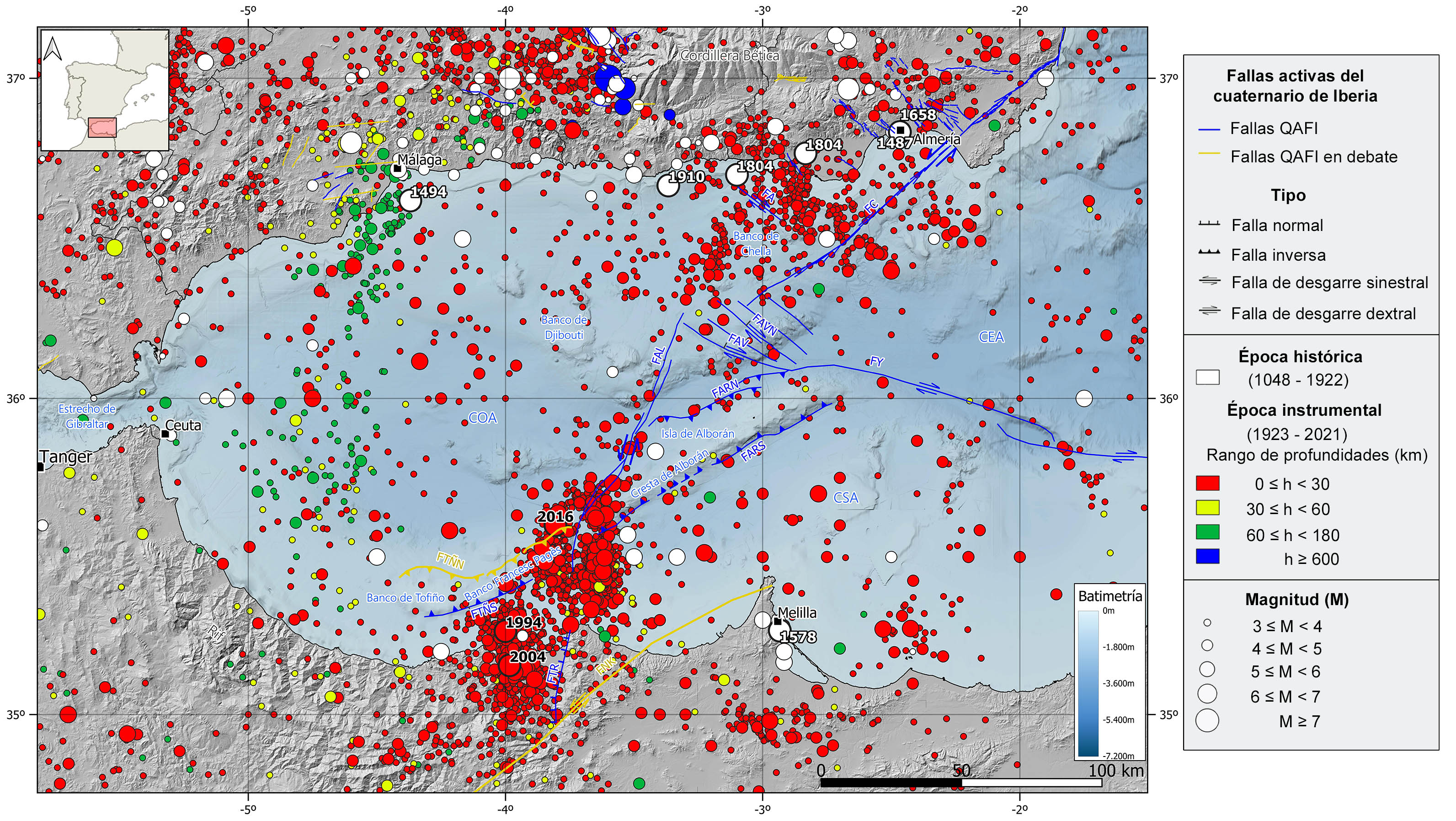
The Alboran domain is one of the most seismically active areas in the western Mediterranean Sea. It is characterized by shallow seismicity (<40 km) of low to moderate magnitude, although several large destructive historical earthquakes have also hit this region. This shallow seismicity is mainly controlled by the active fault systems that cross the basin, with predominant strike-slip focal mechanisms, though some reverse and normal type mechanisms are also observed.
Historically, it is worth mentioning the 1804 earthquake in Dalías (Almería), with maximum intensity VIII-IX and estimated magnitude of 6.4, which caused around 400 deaths and the destruction of most of the buildings in Dalías, Berja and Roquetas. Also noteworthy are several earthquakes of intensity VIII and VII-VIII and estimated magnitudes around 6.0, such as those occurred in Almería in 1487 and 1658, the 1494 earthquake located offshore Málaga, the 1578 earthquake in Melilla and two earthquakes in Adra, one in 1804 which may have generated a small tsunami that affected the Spanish and African coasts, and another one in 1910.
During the instrumental period, most of the seismicity is clustered in the southern part of the basin, around the Al-Idrisi fault (FAL) and north of the Moroccan coast, although many shallow earthquakes have also been registered in the northern Alboran basin, around the Adra and Carboneras faults (FA and FC, respectively). Since 1990, there have been three main seismic episodes. The first one in 1994 with a magnitude of 6 to the northwest of Alhoceima city (Morocco), felt with intensity V in Melilla. The second one in 2004, with a main event of magnitude 6.2 located to the south of Alhoceima (Morocco), where was felt with a maximum intensity of VIII causing numerous damages to buildings and a large number of casualties. And a third episode in 2016 located in the Alboran Sea, near the central-to-south segment of Al-Idrissi fault. This seismic series began with a foreshock of magnitude 5.1, followed by a main shock of magnitude 6.3, both located about 100 km to the NW of Melilla. This event was widely felt in the south of Andalucía, Ceuta and Melilla, where a maximum intensity of VI was observed, and slight damage was caused. This is the maximum magnitude known in this area. Since 2021, thousands small-magnitude (M<3.0) shallow earthquakes, without a clear main shock (seismic swarm), are being recorded near the 2016 series epicentral area but located to the east of Al-Idrissi fault. The largest events recorded between 2021 and 2023 are two earthquakes of magnitude slightly above 5.0.
There is also a significant set of earthquakes occurring at intermediate depths (40-150 km) in the western part of the Alboran basin, whose epicenters are aligned NNE-SSW from Málaga to the coast of Morocco. The existence of this seismicity has given rise to different theories about its origin on which there is still no agreement. Some of the most accepted are the existence of a subduction slab of Atlantic oceanic lithosphere under the Gibraltar Arc with an eastward dip that becomes practically vertical at depth, or the occurrence of different delamination processes under the Alboran Sea.
| © Instituto Geográfico Nacional - C/ General Ibáñez de Ibero, 3. 28003 Madrid - España.
sismologia@transportes.gob.es |


