

Structure and Functions
Structure
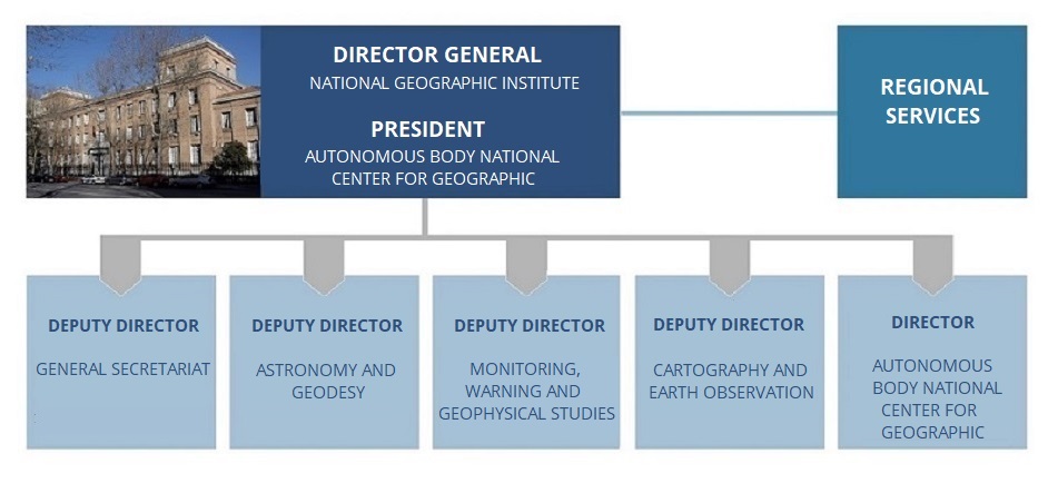
The current structure of the Directorate-General of the National Geographic Institute is contained in Article 16 of Real Decreto 253/2024, de 12 de marzo(new window will open) which develops the basic organisational structure of the Ministry of Transport and Sustainable Mobility, configuring it as a management body attached to the Under-Secretariat of the Department and integrated by the following bodies with the rank of Deputy Directorate Generales:
- Secretariat General.
- Subdirectorate General for Astronomy and Geodesy.
- Subdirectorate General for Cartography and Earth observation.
- Subdirectorate General for monitoring, Warning and Geophysical Surveys.
- National Centre for Geographic Information (CNIG), an autonomous agency with the rank of Subdirectorate General attached to the Directorate-General of the IGN.
Additionally, the Directorate General of the IGN (through the CNIG) depends operationally on a series of territorial units (organically dependent on the Ministry of Territorial Policy and Public Function) called Regional Services, established in the various Autonomous Regions within the Government Delegations. Furthermore, the Geophysics Centre of the Canary Islands adds to its own functions those of a Regional Service, and the Regional Service of Catalonia extends its scope to the Balearic Islands.

Organisational Chart
By clicking on each box you can consult the contact information and the functions assigned to each of the governing bodies as well as the contacts of the Regional Services.
Director General of IGN and President of CNIG
General Director and President of the CNIG: Mr. Lorenzo García Asensio
Vice President of the Superior Geographic Council.
President of the National Commission of Astronomy, of the Spanish Commission of Geodesy and Geophysics, in accordance with the provisions established in their respective regulatory norms.
Telephone: 91 597 94 11 Fax: 91 597 97 53 ign@transportes.gob.es
Secretariat General
Secretary General: Ms. Mónica Groba López
Telephone: 91 597 94 20 21 Fax: 91 597 97 50 ign@transportes.gob.es
Functions
- The management of historical, cartographic, and documentary funds, bibliographic collections, instrument collections, and the remaining historical heritage of the National Geographic Institute, promoting their understanding within society.
- For both its own scope and that pertaining to the National Geographic Information Center (CNIG), the definition of a joint strategic framework and the functional coordination of central and peripheral services, as well as national and international projects.
- The drafting of the preliminary budget proposal and the management and processing of credits and expenses allocated to the management body, as well as handling matters related to contracting and grants within its jurisdiction, without prejudice to the competencies of other higher or management bodies within the Department, and in coordination with them.
- The management of movable and immovable assets and common computer systems used by the Directorate General, without prejudice to the competencies of other management bodies in Information Technologies, as well as collaboration on human resources policy, internal regulations, occupational risk prevention, and other common services, with the competent management bodies, in accordance with the guidelines of the Undersecretariat.
- Likewise, it will exercise, through the Technical Secretariat of the Superior Geographic Council, the functions described in section 1.ñ) and those attributed in Royal Decree 1545/2007, of November 23, which regulates the National Cartographic System.
Subdirectorate General for Cartography and Earth observation.
Deputy Director: Mr. Francisco Javier González Matesanz
Telephone: 91 597 95 89 Fax: 91 597 97 65 ign@transportes.gob.es
Functions
- The direction and development of national land observation plans with cartographic application, as well as the use of photogrammetry and remote sensing systems, and the production, updating and exploitation of digital elevation models.
- The production, updating, and exploitation of databases concerning the topographic aspects of the Geographic Reference Information outlined in Annex I of Law 14/2010, of July 5, regarding the infrastructures and geographic information services in Spain, encompassing high-value data related to digital transport networks and infrastructures, hydrographic elements, geographic location and geometric delimitation of population entities, as well as the spatial and thematic description of land use. Additionally, the inclusion of BIM models in the national digital geoinformation databases.
- The programming of the National Cartographic Plan and the production, updating, and exploitation of topographic and cartographic databases nationwide for integration into geographic information systems, as well as for the creation of the National Topographic Map and other basic and derived cartography. Additionally, the production and updating of the National Atlas of Spain, the provision of technical assistance in cartography to public bodies, as well as the management of cartographic laboratories and workshops.
- The production and updating of thematic cartography to support specific action programs of the General State Administration.
Subdirectorate General for Astronomy and Geodesy.
Deputy Director: Mr. Jose Antonio López Fernández
Telephone:91 597 94 60 Fax: 91 597 96 16 ign@transportes.gob.es
Functions
- The planning and scientific exploitation of proprietary astronomical instrumentation and infrastructures, including conducting research focused on radio astronomy, as well as providing official information on astronomy and preserving the heritage of the Royal Observatory of Madrid.
- The technological development and operational management of proprietary instrumentation and infrastructures for radio astronomy, space geodesy, and geodynamics, especially for the operation of the Yebes Observatory as a unique scientific and technical facility.
- The operation and development of the Atlantic Network of Geodynamic and Spatial Stations (RAEGE) as fundamental geodetic stations of the Global Geodetic Observing System (GGOS) for monitoring Earth's geodynamic parameters and contributing to the terrestrial reference framework for sustainable development.
- The planning and management of national geodetic and gravimetric networks, high-precision leveling networks, and tide gauge networks that comprise the Spanish Geodetic Reference Framework and System, the exploitation and analysis of geodetic and geodynamic observations, the development of applications for navigation systems, positioning, and sustainable mobility, as well as the execution of related works and studies.
O.A. National Centre for Geographic Information (CNIG)
Director: Mr. Emilio López Romero
Telephone: 91 597 96 46 Fax: 91 597 97 64 consulta@cnig.es
Functions
- Those established by Real Decreto 310/2021 de 4 de mayo (BOE núm. 121, de 21 de mayo de 2021) (se abrirá nueva ventana), which amends the Statute of the National Centre for Geographic Information.
- Production and updating of thematic cartography to support specific action plans from the central state administration.
- Planning and management of the Spanish Geographic Information Infrastructure, as well as alignment and standardization in the framework of the National Cartographic System for official geographic information. Likewise, the planning and development of value-added services and new systems and applications in terms of geographic information, especially for use by Public Administrations.
- It shall act as a specialised unit for the dissemination, distribution, promotion, marketing and exploitation of geographic data, products, services and applications.
- Management of the geospatial technological infrastructure of the General Directorate of the National Geographic Institute.
- Participation and participation in research projects and institutional representation in geographic matters, within the strategic framework defined by the Directorate General of the National Geographic Institute.
- The Autonomous Body of the National Centre for Geographic Information, for the purposes of obtaining and managing public funding, may develop and participate in the R&D&I and scientific-technological investment projects that the Directorate General of the National Geographic Institute determines in the terms and matters of its own competence.
- Regional Services and the Peripheral Services of the Directorate General of the National Geographic Institute will support the activities carried out by the Autonomous Body of the National Centre for Geographic Information, in the territorial area that corresponds to them, as long as they respond to the powers attributed to said Directorate General by the Autonomous Body of the National Centre for Geographic Information, or to the latter's own powers, in accordance with its Statute, with the legal instruments that correspond to it in each case.
The Subdirectorate General for Monitoring, Warning and Geophysical Surveys
Deputy Director: Dña. Carmen López Moreno
Telephone: 91 597 94 60 +34 627625937 Fax: 91 597 96 16 ign@transportes.gob.es
Functions
- Coordination of the preparation, development and monitoring of the National Plan for seismic, volcanological and other geophysical phenomena monitoring.
- The planning and management of systems for detecting and notifying institutions of seismic movements occurring on national territory and their possible effects on the coasts, as well as carrying out work and studies on seismicity and coordinating seismic-resistant regulations.
- Planning and management of systems for observation, monitoring and communication to institutions of volcanic activity and determination of associated hazards, as well as management of geomagnetism observation systems and related work and studies.
- The planning and management of monitoring , communication, and alert systems for institutions regarding tsunamis that may affect the Spanish coastlines, as well as participation in international tsunami alert networks and the execution of works and studies in the field of early warning systems and tsunami hazard assessment.
- Acting as the National Data Center for the Preparatory Commission for the Comprehensive Nuclear-Test-Ban Treaty Organization (CTBTO) and managing the primary seismic station PS40 of the CTBTO International Monitoring System.
- The planning and management of monitoring, communication, and alert systems for institutions regarding volcanic activity and determination of associated hazards in Spanish territory and around Spanish Antarctic bases, as well as the execution of works and studies in the field of volcanology and early warning of eruptive processes.
- The planning and management of networks for observing the Earth's magnetic field and its contribution to international networks for global observation, as well as the observation and monitoring of geomagnetic disturbances originating from solar activity and their effects on national territory, the development of geomagnetic mapping, and the execution of works and studies on geomagnetism.
Functions
Royal Decree 308/2022, which establishes the basic organic structure of the Ministry of Transport and Sustainable Mobility and includes in its article 16 the functions and competences entrusted to the Directorate General of the IGN.
To see the functions assigned to this Directorate-General, please consult this document.